- 12741 Research Blvd. Suite 500 Austin, TX
- sales@rastracmarinevision.com
- (877) 680-1188
Geofencing for rental watercraft is transforming the way marinas and rental operators manage safety, compliance, and asset protection. With Marine Vision by Rastrac, operators can create precise virtual boundaries, monitor vessel activity in real time, and automate alerts or actions that protect both their assets and their customers.
Geofencing works by combining GPS tracking technology with specialized fleet management software to create virtual boundaries on the water. When a watercraft equipped with a GPS tracker crosses one of these invisible perimeters, the system automatically triggers predefined actions such as sending alerts or logging the event for review.
With Marine Vision by Rastrac, these boundaries are fully customizable — allowing operators to tailor geofences to their unique rental areas, no-wake zones, or restricted waters.
Using the Marine Vision by Rastrac dashboard, operators can easily draw geofences on a digital map around:
Authorized operating zones
“No-wake” areas
Restricted or prohibited locations such as shipping lanes, marine sanctuaries, or shallow waters
These perimeters can be circular, polygonal, or corridor-shaped, defined by precise GPS coordinates.
Each rental watercraft —whether a jet ski, pontoon, or powerboat — is equipped with a GPS tracking device. This device continuously receives satellite signals to determine the vessel’s:
Real-time location
Speed
Direction of travel
The tracker then transmits this data to Marine Vision by Rastrac, where operators can monitor every vessel from a single, centralized platform.
Once a geofence is defined, Marine Vision by Rastrac constantly compares vessel positions with those boundaries.
If a watercraft crosses one, the system can instantly:
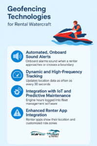
⚠️ Instant Notifications: Operators receive immediate SMS, email, or in-app alerts about the breach.
🔈 Audible Alerts: The renter may hear a buzzer or see an in-app message indicating they’ve left the permitted area.
🔒 Engine Immobilization: For serious violations or theft prevention, the engine can be safely disabled remotely.
Every geofence interaction is recorded automatically within Marine Vision by Rastrac for full traceability and reporting. Key data logged includes:
Event type (entry, exit, or boundary breach)
Timestamp and exact GPS coordinates
Watercraft ID and renter info
Duration of the event
Speed and heading during the incident
Alerts sent or automated actions triggered
This information provides valuable insights for safety audits, compliance, maintenance planning, and insurance documentation.
Rental operations can use Marine Vision by Rastrac to set up geofences for: 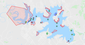
✅ Authorized Operating Zones: Define safe areas within range of the rental base.
🕊️ No-Wake Zones: Automatically enforce local speed limits near marinas or docks.
🔐 Theft Prevention Zones: Detect after-hours movement with geofences around docks and storage areas.
📏 Distance-from-Shore Boundaries: Maintain regulatory distances from beaches or swim areas.
Create a perimeter around the marina or dock to detect any unauthorized movement after hours.
Keep renters within safe waters and away from hazards such as underwater debris, sandbars, reefs, shallow shoals, and heavy traffic zones.
Receive instant alerts about unauthorized movement and track stolen assets in real-time.
Automatically enforce local boating laws like “no-wake” zones to avoid fines or liability.
Monitor all vessels on a single dashboard, optimize maintenance schedules, and improve fleet turnaround times.
Marine Vision by Rastrac is a comprehensive marine fleet management platform designed for rental operators, marinas, and commercial watercraft businesses. Its geofencing capabilities go beyond simple alerts — providing real-time data, safety enforcement, and powerful reporting tools that help operators run more efficiently and profitably.
With Marine Vision, you can:
Create and customize multiple geofence types
Automate safety responses
Monitor all vessels in real time
Analyze fleet performance through data-driven reports