Lake Heat Maps & Depth Tracking: A Must-Have for Recreational Powerboaters

Lake Heat Maps & Depth Tracking: A Must-Have for Recreational Powerboaters

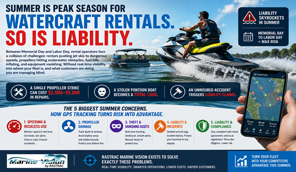
For recreational powerboaters, lake levels and depth variations are critical for safety, performance, and navigation. While water levels fluctuate seasonally, understanding historical depth trends can help boaters avoid hazards, plan efficient routes, and make the most of their time on the water.

How Historical Lake Heat Maps & Depth Tracking Benefit Powerboaters

  1. Avoiding Shallow Areas & Navigational Hazards
    • Water levels change over time, and historical depth data helps boaters understand which areas may become too shallow during certain seasons.
    • Submerged hazards like sandbars, fallen trees, and rocks can be marked by users on their maps, creating a customized navigation guide.
  2. Optimizing Speed & Performance
    • Powerboaters can reference historical depth maps to locate consistently deeper channels that allow for higher speeds and smoother rides.
    • Tracking past depth trends helps boaters identify safe areas for cruising without the risk of propeller or hull damage.
  3. Enhancing Wakeboarding, Waterskiing & Tubing
    • Certain parts of a lake may historically maintain stable depths, making them ideal for water sports.
    • Users can mark their preferred recreation spots on their maps for easy reference and safer boating.
  4. Planning Routes & Understanding Seasonal Water Level Changes
    • While automatic lake level monitoring is not available everywhere, historical data can help predict trends in areas where levels fluctuate.

How Rastrac Helps Powerboaters Navigate with Confidence

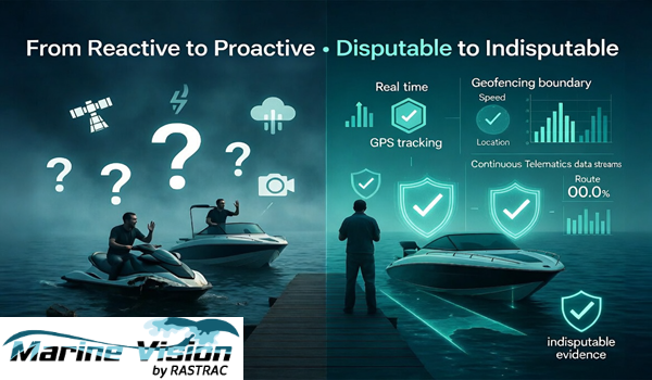
Rastrac offers historical heat mapping and depth tracking tools that allow powerboaters to better plan routes, track water level trends, and mark potential hazards.

  • Historical Depth & Water Level Trends – Use past data to plan the best routes and avoid seasonal shallows.
  • Custom Location Marking – Identify submerged hazards, docks, and recreation spots on your personalized map.
  • Lake Level Monitoring – Where data is available, customers can access historical lake level data to assist with trip planning.
  • GPS-Based Mapping & Navigation Support – Get better situational awareness with location tracking and user-generated insights.

By utilizing historical lake data and customizable mapping tools, Rastrac helps powerboaters enjoy a safer, smoother, and more predictable experience on the water.

Related Articles from the Archives:

Preventing Propeller Damage: How Rastrac Helps Boat Clubs and Rental Companies Avoid Costly Damage

For boat clubs and rental companies, one of the most frustrating and expensive challenges is dealing with damaged propellers. Operators - whether inexperienced renters or even seasoned members—sometimes stray into restricted areas, such as shallow waters, sandbars, or protected zones, resulting in costly repairs and downtime. Fortunately, Rastrac’s advanced GPS tracking and geofencing solutions provide an effective way to mitigate these risks and protect your fleet.

5 Ways to Prevent Watercraft and Boat Theft

Thousands of watercraft and boats are stolen every year, resulting in tens of thousands of dollars in lost property. What steps can you take to ensure you don’t fall victim to criminals? There are a few security measures to implement and equipment to consider utilizing when it comes to protecting your watercraft or boat from theft.

Have questions or want to schedule a demo?

Reach Out Today

Rastrac complements any organization-wide quality assurance program and can help their fleet become the model for operational superiority.

Rastrac helps clients make improvements in processes, organization, financials, communications, and technology. Clients that have taken advantage of Rastrac’s ability to provide solutions tailored to their business are in a wide variety of industries. Rastrac can help you find a solution, too.

We’d love to discuss how we can help you.