- 12741 Research Blvd. Suite 500 Austin, TX
- sales@rastracmarinevision.com
- (877) 680-1188
Your charter operation just lost a $45,000 speedboat to preventable propeller damage. A rental pontoon boat went out of bounds and hit rocks you specifically marked off-limits. Your fishing fleet spent an hour searching for a missing jet ski that should have triggered location alerts 10 minutes into the no-go zone.
These aren’t hypothetical scenarios; they’re the daily reality for watercraft operators without proper GPS tracking. Standard consumer GPS trackers designed for cars perform poorly in coastal waters, where GPS signals bounce off water, buildings, and ocean swells. You need marine-specific hardware and software built for the unique challenges of tracking everything from personal watercraft to multi-boat rental fleets.
Rastrac Marine Vision solves this with hardware engineered specifically for water operations and a platform designed around the realities of marine asset management. Here’s why accuracy matters in coastal tracking, which solution fits your operation, and how to deploy marine GPS the right way.
Standard GPS accuracy of ±100 meters works fine for knowing whether a truck is on Highway 285 or Highway 87. It doesn’t work for knowing whether your wakeboard boat is in the designated ski zone or drifting toward rocks.
Rastrac Marine Vision achieves ±10 feet accuracy in coastal waters—a 10x improvement over standard GPS. This precision comes from purpose-built marine hardware combined with coastal-specific software optimization.
Water reflects and scatters GPS signals differently than land. Radio waves bounce off the ocean surface, creating multipath errors where the receiver picks up the same signal arriving from multiple directions. Salt water additionally attenuates (weakens) satellite signals compared to freshwater. Buildings and structures near marinas create urban canyon effects that block direct satellite sight lines. Commercial shipping, bridge infrastructure, and coastal clutter compound the problem.
Consumer GPS devices, even premium ones, aren’t tuned for these specific conditions. Marine Vision hardware, by contrast, uses active GPS antennas with integrated amplification (low-noise amplifier or LNA) specifically tuned for marine signal characteristics. The antenna placement on the center-line of a pontoon boat or the T-top of a center console optimizes satellite geometry. The software filters out multipath reflections and uses heading information to validate position updates.
The ST4215 water-resistant tracker and ST9100 hybrid device both stream real-time speed data to the Marine Vision platform. Speed exceeding safe thresholds for the zone (ski zones: 15 mph, no-wake areas: 5 mph, open ocean: unrestricted) triggers immediate captain alerts via text or push notification. One Rastrac customer documented a 75% reduction in propeller damage in the first boating season, achieved because captains now receive speed warnings before they enter shallow water at unsafe velocities.
Choosing between Rastrac’s two marine tracking devices depends on where your watercraft operates and whether you need coverage beyond coastal cellular range.
The ST4215 is purpose-built for rental operations, charter fleets, and day-boat owners whose watercraft stay within cellular coverage (typically within 20-30 miles of shore, depending on network).
Ideal for:
Coverage:
Tracking Performance:
Advantages:
The ST9100 is engineered for situations where you need tracking beyond coastal cellular coverage; offshore fishing operations, multi-day charters, or open-ocean deployments. This hybrid device automatically switches between cellular and satellite communication based on signal availability.
Ideal for:
Coverage:
Tracking Performance:
Advantages:
Comparative Decision Matrix:
| Feature | ST4215 | ST9100 |
| Accuracy | ±10 ft coastal | ±10 ft coastal |
| Coverage Range | 20-30 mi from shore | Unlimited (global) |
| Monthly Cost | Lower | Higher (satellite) |
| Update Frequency | 10-30 sec | 10-30 sec (cell) / 5-10 min (sat) |
| Best For | Rental fleets, charter day ops | Offshore, multi-day, remote |
| Battery | Boat power required | Boat power + battery backup |
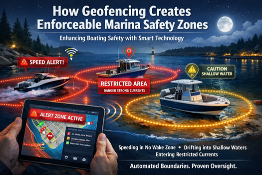
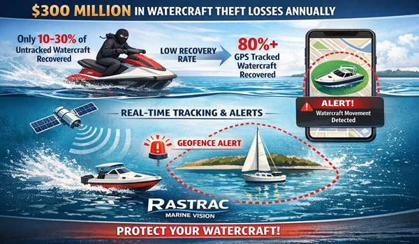
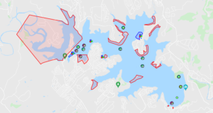
The real value of marine GPS tracking in coastal waters isn’t just knowing where your watercraft is, it’s automatically preventing damage before it happens. Geofencing, available through Marine Vision, creates virtual boundaries around dangerous areas, shallow zones, and rental limits.
Create boundaries around no-wake zones, ski areas, and shallow channels. When a speedboat or personal watercraft exceeds safe speed for the zone, the captain receives an immediate alert. One rental operator reduced propeller strikes by 75% simply by enabling speed alerts as boats approached shallow areas.
Rental agreements specify geographic limits (e.g., “no operation beyond the 10-mile marker”). Marine Vision displays these boundaries in real-time on the captain’s phone and alerts dispatch if a jet ski or wakeboard boat drifts beyond the approved zone. Geofence exit triggers an immediate text to both captain and dispatch, enabling fast intervention before damage occurs.
Marina operators create exclusion zones around fuel docks, launching ramps, and congested mooring fields. Entry into these high-traffic areas triggers alerts to ensure safe maneuvering speeds and proper crew coordination.
Review exactly when watercraft entered/exited zones, duration inside geofences, and patterns over time. Identify if a captain consistently ventures beyond authorized boundaries or if renters are using equipment outside contracted terms.
Understanding how ±10 feet accuracy translates to operational reality helps you appreciate why marine-specific GPS matters.
A charter operator runs a 4-hour fishing trip with planned stops at three locations. With standard ±100m GPS, the boat’s position could be off by 330 feet, enough to confuse which reef you’re near. With Marine Vision’s ±10 feet accuracy, the captain sees precisely which structure the boat is over. This enables faster navigation between hot spots, reduces time spent repositioning, and improves catch rates.
You hear a grinding sound. Is it a submerged log, a rock, or shallow water? With Marine Vision tracking location to ±10 feet and depth-water data available through sensor integration, your maintenance team immediately knows the impact location and can assess the risk. A log hit in 8 feet of water is different from a rock strike in 3 feet and accuracy matters for damage assessment.
A renter rents a pontoon boat with a $12,000 Mercury outboard. They exceed speed limits in a no-wake zone, something that happens 5-10 times per rental fleet per season. With Marine Vision geofencing and speed monitoring, dispatch receives an alert within 30 seconds and can radio the renter with a safety reminder before propeller damage occurs. One customer documented a substantially reduced amount of downtime within their fleet, increasing overall revenue after implementing Marine Vision tracking and geofencing.
Q: Can I use a standard consumer GPS tracker (like an AirTag or Tile) on my fishing boat?
A: Consumer trackers are designed for finding lost items within cellular range, not real-time fleet tracking. They lack marine-grade water sealing, offer no speed monitoring or geofencing, and don’t integrate with fleet management software. Marine Vision hardware includes marine-specific antennas, faster update intervals, and coastal optimization that consumer devices simply don’t provide. For a rental or charter operation, consumer trackers would leave you blind to speed violations, boundary violations, and damage-risk situations that Marine Vision prevents.
Q: What if my watercraft goes temporarily out of cellular range?
A: If you’re operating within coastal cellular coverage (ST4215), brief cellular dropouts are normal and expected. The ST4215 stores position data locally on the device and syncs when connectivity returns. For operations that regularly go beyond 20-30 miles from shore or into remote coastal areas, the ST9100 hybrid LTE/satellite device is the right choice—it maintains continuous coverage by automatically switching to satellite when cellular is unavailable. Contact Rastrac sales to assess your typical operating area and coverage requirements.
Q: How is ±10 feet accuracy achieved compared to standard ±100m GPS?
A: Marine Vision uses specialized marine hardware with active GPS antennas tuned for coastal signal characteristics, multipath filtering software optimized for water environments, heading validation to reject invalid positions, and optimal antenna placement on your watercraft. Standard GPS doesn’t optimize for these marine-specific factors. The 10x accuracy improvement comes from hardware engineering and software algorithms specifically built for the challenges of tracking watercraft in coastal zones.
Q: What maintenance does the tracker require?
A: ST4215 and ST9100 devices are sealed IP67 enclosures with no user-serviceable parts. Your watercraft’s 12V or 24V system powers the device—no separate batteries to maintain. The only maintenance is verifying the device is reporting properly through the Marine Vision dashboard. Rastrac handles all firmware updates automatically over-the-air (OTA).
Q: Can I track multiple watercraft (our entire rental fleet) from one Marine Vision account?
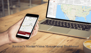
A: Yes. Marine Vision is built for multi-watercraft fleet management. See real-time location of all boats on a unified map, receive geofence alerts for all watercraft simultaneously, generate reports across your entire fleet, and manage user access by role (captains, maintenance, dispatch, management). One rental operator tracks 100+ watercraft from a single dashboard, reducing manual fleet monitoring by approximately 80%.
Propeller damage, unauthorized boundaries, and the friction of finding out-of-range watercraft are preventable with purpose-built marine GPS. Rastrac Marine Vision delivers ±10 feet coastal accuracy, geofencing that stops damage before it happens, and a platform engineered specifically for how watercraft operators actually work.
Your next step is simple: understand which of your watercraft need continuous tracking and whether your operation includes offshore or remote areas. The ST4215 works for most coastal rental and charter operations; the ST9100 handles everything from nearshore to open ocean.
Request a Demo | Purchase Online | (877) 680-1188 | Contact Us