- 12741 Research Blvd. Suite 500 Austin, TX
- sales@rastracmarinevision.com
- (877) 680-1188

Picture walking into your marina office at 6 AM. Before your first coffee, you know exactly which rental pontoon boats returned late last night, which center console is due for its 100-hour service, and that the fuel dock will hit peak demand at 9:47 AM based on historical patterns. You didn’t check a single clipboard or walk a single dock. Your digital twin – built from GPS tracking data – already mapped your entire operation while you slept.
That’s the power of operational intelligence. What looks like dots on a map to most marina operators becomes a living, breathing model of your business when you understand what GPS data actually reveals. The fishing boats circling the same reef every weekend aren’t just rental income; they’re predictive maintenance events waiting to happen. The jet skis that always push geofence boundaries aren’t just liability concerns; they’re training opportunities for tomorrow’s rental briefing. Every position report, every engine hour, every speed alert contains operational intelligence waiting to be extracted.
Most marina operators think GPS tracking means watching boats move on a screen. A digital twin is fundamentally different. It creates a virtual replica of your physical marina that updates in real-time and learns from historical patterns. When a wakeboard boat crosses into a no-wake zone, your digital twin doesn’t just show that violation – it shows this is the third time this month that particular watercraft has triggered that geofence, during rental agreements handled by two different staff members, suggesting either unclear signage or inadequate customer briefing.
Rastrac’s Marine Vision platform transforms basic location data into operational intelligence through multi-layered analysis. Position accuracy within 10 feet means you know exactly which slip a sailboat occupies, not just that it’s “somewhere in B dock.” Engine hour tracking reveals that your bass boat rentals average 4.2 hours per trip while your pontoon boats average 6.8 hours – completely different wear patterns requiring different maintenance schedules. Battery voltage monitoring predicts which personal watercraft will need jump-starts before customers complain.
The intelligence emerges from context, not just coordinates. A speedboat traveling 45 MPH tells you nothing by itself. That same reading near the fuel dock at 2PM on Saturday, for the third consecutive weekend, tells you everything: this renter consistently pushes speed limits, creates wake near docked boats, and will likely generate a safety incident within 30 days unless intervention occurs. Your digital twin connects those data points automatically.
Physical marinas have docks, slips, and buoys. Digital twins have geofences, virtual boundaries that trigger intelligence gathering. Create a circular geofence around your fuel dock and you suddenly measure wait times, identify peak congestion windows, and calculate exactly how long each refueling transaction takes. Polygon geofences following your rental boundaries automatically detect when jet skis stray into restricted waters, generating not just alerts but compliance records for insurance purposes.
Rastrac supports unlimited geofences with entry/exit notifications, meaning you can map every operational zone that matters. Service areas for your workboats. No-wake zones matching local ordinances. Rental boundaries matching your insurance policy. Dangerous current areas where inexperienced boaters get into trouble. Each geofence becomes a data collection point, feeding your digital twin information about how customers actually use your watercraft versus how you think they do.
The compound effect of geofencing reveals operational patterns invisible to manual observation. Your digital twin might show that 73% of propeller damage occurs within 200 feet of the same shallow reef, despite prominent warning buoys. Armed with that intelligence, you modify rental briefings, adjust insurance deductibles for that zone, or add a corridor geofence that alerts renters before they enter danger areas. One marina reduced propeller damage by 75% in the first season after implementing this type of intelligence-driven geofencing strategy.
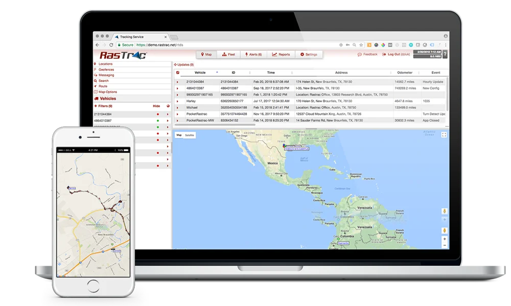
Traditional marina management means walking docks with a clipboard, manually checking which boats returned, which need fuel, which sit idle. The digital twin eliminates this entirely. Log into Rastrac’s web-based platform and see every watercraft simultaneously: which fishing boats are underway, which catamarans are docked, which bowriders are approaching the fuel dock. Color-coded status indicators show ignition on/off, movement versus stationary, maintenance due, and battery levels without you touching a single key fob.
This real-time visibility transforms operational workflows. When a customer calls asking about center console availability, you don’t say “let me check and call you back” – you pull up the live map and see that two are docked, one is 12 minutes from return based on current position, and one is in the service bay with a maintenance flag. Instant, accurate answers that convert inquiries into revenue. When a renter reports a jet ski issue, you dispatch your workboat to the exact coordinates rather than searching 200 acres of water based on a vague description of “near the lighthouse.”
The ST4215 water-resistant tracker and ST9100 hybrid LTE/satellite device provide the location accuracy this intelligence requires. Within 10 feet precision means distinguishing between slip A-23 and A-24, not just knowing a yacht is “somewhere in the A dock range.” For offshore operations or large water bodies where cellular coverage drops, the ST9100 automatically switches to satellite communication, ensuring your digital twin maintains complete visibility regardless of where watercraft roam.
GPS data becomes exponentially more valuable over time. Your digital twin doesn’t just show where boats are now – it reveals where they’ve been, when, how often, and under what conditions. This historical layer uncovers revenue optimization opportunities impossible to spot manually. Armed with that intelligence, you adjust pricing or preferentially assign premium rentals to high-turnover locations.
Maintenance scheduling transforms from guesswork into precision. Rather than servicing every pontoon boat at arbitrary 50-hour intervals, your digital twin allows you to schedule maintenance based on actual usage patterns, reducing downtime for light-use boats and preventing failures on heavy-use boats. Battery voltage monitoring adds another layer – when historical data shows a personal watercraft consistently drops below 12.4V after six hours of operation, you know that battery is degrading before it strands a customer.
Fuel dock optimization is another intelligence goldmine. Reviewing geofence data shows you handle an average of 14 refueling transactions between 9:30 AM and 10:15 AM every Saturday, creating a congestion bottleneck that frustrates customers and limits throughput. Your digital twin reveals this pattern, enabling you to adjust staffing levels, incentivize off-peak refueling with small discounts, or add temporary fueling capacity during peak windows. These insights don’t come from intuition; they emerge from systematic analysis of thousands of geofence entry/exit events over months of operation.
Traditional marina maintenance is reactive: you service watercraft when they break or hit arbitrary calendar milestones. Digital twin intelligence makes maintenance predictive. Engine hour reports show exactly when each sailboat, speedboat, and fishing boat crosses the 100-hour service threshold. You schedule service during natural low-utilization periods identified through historical data rather than pulling profitable rentals off the water.
Marine Vision by Rastrac’s maintenance management system integrates directly with GPS data. Create custom maintenance plans tied to distance, time, engine hours, or combinations thereof. The platform sends email and text notifications when service is due, tracks maintenance history, and logs fuel consumption patterns that might indicate developing mechanical issues. When your bass boat’s fuel efficiency drops 15% over three weeks despite consistent usage patterns, the digital twin flags this as a probable engine issue requiring inspection.
Workboat fleet management becomes exponentially more efficient. Track your service skiffs, maintenance craft, and staff boats with the same precision as customer rentals. When a renter reports a disabled jet ski, dispatch the nearest workboat based on real-time positions rather than radio calls asking, “who’s closest to the north buoys?” Monitor workboat utilization to identify whether you’re understaffed during peak seasons or carrying excess capacity during shoulder months. The same GPS intelligence that manages customer watercraft optimizes your support fleet.
Slip assignments seem straightforward until you map them in a digital twin via API into your marina management software such as FareHarbor. Geofence each slip and suddenly you have occupancy analytics showing exactly how many days per month each location is utilized, which slips command premium pricing based on demand patterns, and which sit empty while creating maintenance costs. This intelligence drives pricing strategy, marketing focus, and capacity planning decisions worth thousands in incremental revenue.
Seasonal patterns become crystal clear through historical data. Your digital twin might reveal that pontoon boat demand peaks May through September while fishing boat rentals remain steady year-round. Armed with this intelligence, you adjust your fleet mix, negotiate better off-season storage rates for seasonal boats, and optimize dock space allocation to maximize revenue per square foot. The data might show that 30-foot sailboats generate 40% more revenue per slip than 25-foot sailboats, justifying infrastructure investments in larger slip configurations.
Customer behavior intelligence helps too. Tracking shows that renters who launch before 7 AM return 92% of watercraft on time, while those launching after 11 AM return only 67% on time. You adjust deposit structures, modify rental terms, or offer early-bird pricing incentives to shift demand toward higher-compliance time windows. These insights don’t require hiring consultants, they emerge automatically from GPS data your digital twin has been collecting since installation.
Humans are terrible at spotting patterns in thousands of data points. AI excels at it. When your digital twin accumulates 90 days of GPS tracking data across 50 watercraft, that’s millions of position reports, speed measurements, engine hour readings, and geofence interactions. AI analyzes this ocean of data to surface insights no marina manager could spot manually: jet ski rentals initiated between 2-4 PM on weekdays generate 300% more speed violations than weekend morning rentals, suggesting either different customer demographics or insufficient afternoon staffing for proper safety briefings.
Predictive analytics become possible with sufficient historical data. AI models might predict that based on current utilization trends, your bowrider fleet will hit capacity 14 times this summer – up from 8 times last summer – enabling you to secure additional rental boats before peak season begins. Weather pattern analysis combined with GPS data might reveal that wind speeds above 18 MPH correlate with 60% drops in sailboat rentals but only 20% drops in pontoon boat rentals, helping you optimize marketing spend around weather forecasts.
Anomaly detection is another AI strength. When a center console that normally averages 22 MPH suddenly maxes at 15 MPH for three consecutive rentals, the AI flags this as a probable propeller fouling issue requiring inspection. When a personal watercraft consistently returns with lower battery voltage than other units in the fleet despite similar usage patterns, the AI predicts battery replacement before failure occurs. These early warning systems prevent customer dissatisfaction and reduce emergency repairs.
The ultimate value of AI intelligence is actionable recommendations. Your digital twin in conjunction with your marina management software via API doesn’t just show you patterns, it suggests what to do about them. “Based on historical utilization data, moving your three most popular fishing boats to slips with faster launch access will reduce average rental processing time by 12 minutes, enabling 3.4 additional daily rentals during peak season.” That single insight could generate $15,000 in incremental annual revenue.
Route optimization applies to marina operations too. If your workboat spends an average of 47 minutes per day traveling between the fuel dock, service slips, and storage areas, AI might recommend relocating your fuel storage to reduce that to 31 minutes – saving 16 minutes daily that compounds to 97 hours annually. For a service technician earning $35/hour, that’s $3,395 in recovered labor costs, potentially justifying infrastructure modifications that previously seemed unnecessary.
Staff scheduling optimization leverages GPS intelligence about when and where work actually happens. If historical data shows your busiest service windows are Tuesday mornings and Friday afternoons (not Monday mornings as you assumed), AI recommends shifting your senior technician’s schedule accordingly. If refueling demand peaks 45 minutes earlier on holiday weekends than regular weekends, AI flags this pattern early in the season, enabling proactive schedule adjustments before customer complaints arise.
The digital twin doesn’t exist in isolation; it integrates with your existing marina management systems such as Fare Harbor. Rastrac’s web-based platform connects to nearly any modern business software through API integrations, meaning GPS data flows directly into your accounting software, CRM system, maintenance management platform, or custom dashboards. When a rental yacht crosses the geofence boundary marking end-of-rental, that event can automatically trigger invoice generation, deposit processing, and the next customer’s notification that their boat is ready.
PocketRastrac mobile app transforms smartphones and tablets into tracking devices, enabling staff to update the digital twin from anywhere in the marina. A dock attendant spots a low battery indicator on a personal watercraft? Log it instantly in the app rather than walking back to the office. A maintenance technician completes a repair on a fishing boat? Update the work order status in real-time rather than waiting for end-of-shift paperwork. This mobile integration keeps the digital twin current without creating administrative burden.
Custom reporting pulls intelligence out of the digital twin in formats that drive decisions. Generate weekly utilization reports for ownership meetings. Create monthly maintenance summaries for insurance renewals. Export geofence compliance data for regulatory audits. Rastrac offers 25+ standard report types plus custom report creation, meaning you extract exactly the intelligence you need in exactly the format you need it.
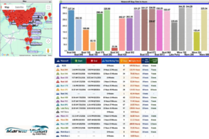
For operators managing multiple marina locations, the digital twin scales to provide consolidated intelligence across all properties. A single dashboard shows which locations have available rental boats, which are at capacity, and which can accept transfers to meet demand spikes. When a customer calls your flagship location, but all speedboats are rented, your digital twin instantly identifies that your second location has two available units, enabling you to capture revenue that would otherwise be lost.
Fleet sharing becomes operationally practical when GPS data provides complete visibility. Move a ski boat from your low-demand winter location to your high-demand tropical location, tracking exactly where it is during the entire transport process. Monitor engine hours, battery status, and location throughout the journey. When it arrives, your digital twin already has complete maintenance history and usage data, eliminating the information gaps that traditionally plague inter-location transfers.
Comparative analytics reveal which locations outperform others and why. If Location A achieves 78% utilization while Location B achieves only 63% despite similar fleet mixes, the digital twin helps identify the root cause: better dock layouts, more effective marketing, superior customer service, or something else entirely. These cross-location insights enable you to replicate success factors and address weaknesses systematically rather than guessing.
How accurate is GPS tracking for marina operations, and does it work indoors or in covered slips?
Marine GPS tracking with Rastrac provides accuracy within 10 feet, which is sufficient to distinguish individual slips and identify exact dock locations. The ST4215 and ST9100 devices work outdoors and in open water environments. For covered slips or indoor storage, the BeMini device includes Wi-Fi and Bluetooth positioning capabilities that maintain location tracking even where GPS satellite signals don’t penetrate. Most marina operations involve primarily outdoor tracking, but hybrid systems can accommodate mixed environments.
What happens to GPS data after 90 days, and can I access historical patterns from previous seasons?
Rastrac stores active data in the live system for 90 days, which is accessible instantly for reports, maps, and analysis. Data beyond 90 days is archived but remains recoverable through Rastrac support upon request. This means your digital twin can access historical utilization patterns from previous summers, maintenance records from last year’s storm season, or multi-year trend analysis for long-term planning. You can also export data in CSV, Excel, or PDF formats for permanent local archiving before the 90-day window expires.
Can GPS tracking help with insurance claims when customers damage rented watercraft or dispute liability?
Absolutely. GPS tracking provides timestamp-verified location data, speed records, and geofence compliance documentation that proves exactly where a boat was, how fast it was traveling, and whether it entered restricted areas. When a customer claims propeller damage “happened in deep water” but GPS shows the boat spent 23 minutes in a shallow geofenced zone with a 6-foot depth restriction, the data resolves disputes conclusively. Many marina operators report that insurers offer premium discounts when comprehensive GPS tracking demonstrates proactive risk management and provides claims documentation.
How do you prevent GPS tracking from becoming overwhelming data noise rather than actionable intelligence?
Rastrac’s intelligent tracking technology uses three-parameter detection (time intervals, distance traveled, and degree of turn) rather than continuous position broadcasting. This means the system reports movement-only events rather than flooding you with redundant data about stationary boats. For most marina applications, programming devices at 2-minute intervals when moving, combined with 800-meter distance detection and 30-degree turn detection, provides high-definition location trails without data overload. Combined with customizable alerts, you receive information about events that matter rather than constant position updates about boats sitting at slips.
What’s the realistic ROI timeline for implementing a digital twin marina management system?
Most marina operators report measurable returns within the first 90 days. A single prevented propeller damage incident (typical repair cost: $800-$2,500) often covers several months of GPS tracking service. Marinas that reduce manual monitoring by 80% recover staff hours’ worth thousands annually. Slip utilization optimization that increases occupancy by just 5% generates incremental revenue that typically exceeds total GPS tracking investment within a single season. The largest ROI comes from compounding benefits: better maintenance scheduling extends equipment life, improved customer safety reduces liability exposure, and historical intelligence drives pricing optimization year after year.
Your marina generates operational data every day – watercraft positions, engine hours, customer behavior, maintenance needs, utilization patterns. Right now, most of that intelligence disappears the moment it happens. A digital twin captures it, analyzes it, and transforms it into the competitive advantage that separates profitable marina operators from those struggling with clipboard-based management.
The technology exists. The platform is proven across thousands of marine operations worldwide. The only question is whether you’ll build your digital twin before your competitors do – or watch them capture the operational advantages while you’re still walking docks with paperwork.
Marine Vision by Rastrac delivers complete digital twin capabilities through GPS tracking devices designed specifically for marine environments. The ST4215 water-resistant tracker handles everything from jet skis to fishing boats, while the ST9100 hybrid LTE/satellite device maintains connectivity even offshore where cellular coverage disappears. Installation takes minutes. Results appear within days. ROI typically shows within the first 90 days through reduced damage, improved utilization, and eliminated manual monitoring tasks.
Stop guessing where your watercraft are. Stop wondering which maintenance is actually due. Stop losing revenue to utilization patterns you can’t see. Start building the digital intelligence system that gives you complete operational control.
Request a Demo | (877) 680-1188 |sales@rastracmarinevision.com