- 12741 Research Blvd. Suite 500 Austin, TX
- sales@rastracmarinevision.com
- (877) 680-1188

• The first 30 minutes of boat rentals account for a disproportionate share of damage claims: inexperienced operators collide with docks, run aground in shallow water, and violate no-wake zones during the critical departure window.
• Geofencing technology reduces rental damage claims by 40-60% by establishing virtual boundaries around hazardous areas, shallow zones, and speed-restricted waters with instant alerts to both operators and rental staff.
• Real-time GPS tracking with audible alarms prevents costly propeller damage and groundings: one rental operation documented a 75% reduction in propeller damage after implementing marine GPS tracking systems.
• Automated boundary enforcement eliminates the “I didn’t know” defense: renters receive instant text and audio warnings the moment they approach restricted areas, creating accountability and preventing damage before it happens.
Every boat rental manager knows the pattern. The customer signs the waiver, receives the safety briefing, and pulls away from the dock with confidence. Twenty minutes later, you get the call: grounded in a sandbar, propeller damage from hitting rocks, or a collision with another watercraft in a no-wake zone.
The first 30 minutes represent the highest-risk window in boat rentals. Operators who’ve never navigated your marina exit channels are suddenly piloting $40,000 pontoon boats through shallow passes they can’t identify. They misjudge distances, miss channel markers, and panic when they realize they’re in three feet of water doing 20 knots. The damage is expensive. The disruption is worse. One fishing boat out of commission for propeller repair costs you thousands in lost revenue during peak season.
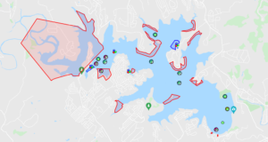
Marine GPS tracking systems eliminate this predictable pattern. Geofencing technology draws virtual boundaries around every hazard, shallow area, and speed restriction in your operating zone. The moment a center console crosses into a restricted area, the operator gets an audible alarm, and you get a text alert. Real-time enforcement prevents damage before metal meets rock.
Rental customers fall into two categories: experienced boaters who think they know your waters, and complete novices who don’t know what they don’t know. Both groups cause damage in the first half hour, but for different reasons.
The overconfident experienced operator assumes every marina operates like the one back home. They ignore your departure briefing because they’ve been boating for 20 years. They blast through your no-wake zone at 15 knots because their home marina doesn’t enforce speed limits. They cut across shallow flats because they’re used to deeper water. Your local knowledge doesn’t transfer to visiting renters, but they don’t realize that until the propeller starts grinding against limestone.
The complete novice follows your instructions exactly until the first unexpected situation. They execute a perfect departure, then panic when another watercraft approaches. They overcorrect, steer into shallow water, and ground the bass boat in six inches of water 200 yards from the dock. They don’t understand depth sounders, can’t read channel markers, and have no intuition for “this water looks too shallow.” Every rental represents a potential incident because they lack pattern recognition.
GPS tracking with geofencing eliminates both problems. Virtual boundaries force compliance regardless of experience level. When a pontoon boat approaches the shallow sandbar that grounds three rentals per month, the system triggers an audible alarm inside the watercraft. The operator hears a loud beep and receives a visual warning on their phone. Your rental desk gets a text alert showing exactly where the pontoon boat entered the restricted zone. The renter can’t claim ignorance – the technology provided real-time warning they chose to ignore or immediately heeded.
Behavioral enforcement works because it removes ambiguity. Experienced operators can’t dismiss your warnings as overcautious local rules. Novices get immediate feedback when they’re about to make a dangerous mistake. The system doesn’t rely on memory, attention, or judgment – it provides intervention at the exact moment intervention prevents damage.
Unfamiliar marina exits create the perfect conditions for rental damage. Operators who’ve never navigated your channel system are suddenly responsible for piloting a 24-foot bowrider through a series of turns with shallow water on both sides. They’re watching for other boats, trying to remember your departure instructions, and completely focused on not looking incompetent. They’re not thinking about depth, channel markers, or the submerged rock formation that damages two propellers every season.
The typical marina exit sequence exposes multiple risk points within minutes. The renter backs away from the dock successfully, then immediately faces a decision: which direction provides the exit channel? Your briefing mentioned turning left at the third marker, but they’re not sure which marker is “first” from their current position. They guess wrong, follow what looks like a channel, and end up in a dead-end cove with a sandy bottom. They try to reverse out, hear grinding noises, and just caused $1,200 in propeller damage before reaching open water.
No-wake zones compound the confusion. State regulations, local ordinances, and marina-specific rules create overlapping speed restrictions that vary by location. A speedboat operator who’s perfectly legal at 25 knots in the main lake suddenly enters a residential cove where anything above idle speed generates complaints and fines. They didn’t see the buoy marking the zone transition because they were navigating around a sailboat. Your rental agreement mentioned no-wake zones but didn’t specify the exact boundaries of all 12 restricted areas in your operating region.
Geofencing solves the marina exit problem by creating a guided departure system. You establish virtual boundaries along the correct exit channel. When a personal watercraft strays outside the designated route, the operator receives an immediate alert: “You are leaving the approved exit channel. Shallow water ahead.” The system provides course correction in real time, preventing the wrong-turn scenario that causes most grounding incidents.
Speed-restricted geofences eliminate no-wake violations. You draw boundaries around every residential area, swimming zone, and environmentally sensitive region in your operating area. The moment a jet ski exceeds 5 knots inside a no-wake geofence, the system triggers alerts. The operator knows instantly they’re violating restrictions. Your rental office receives documentation of the violation with GPS coordinates, speed data, and timestamp. You have evidence for damage deposit deductions and can identify repeat offenders.
The 75% reduction in propeller damage documented by one marine rental operation came primarily from geofencing exit channels and shallow areas. When operators receive audible warnings before entering dangerous zones, they avoid the hazards that cause expensive repairs. The technology converts your local knowledge into automated enforcement that travels with every rental watercraft.
Traditional boat rental operations rely on trust and after-the-fact investigation. You hand customers the keys, watch them leave, and hope they follow the rules. When damage occurs, you piece together what happened from operator explanations that minimize their responsibility. The conversation always includes “I didn’t know,” “there was no sign,” or “the water didn’t look shallow.”
GPS tracking with geofencing creates a different dynamic. Operators know you’re monitoring their location and speed in real time. That awareness changes behavior. The customer who might ignore a no-wake sign thinks twice when they know a geofence violation generates an instant text to the rental office. The temptation to explore unauthorized areas decreases when they understand you’ll receive an alert the moment they cross boundaries.
The accountability effect reduces damage claims by 40-60% according to marine rental operations using geofencing enforcement. Renters take safety briefings seriously when they know the rules are actively monitored rather than suggested guidelines. The “I forgot” excuse disappears when the system proves they received audible warnings at the violation location. Damage deposits become enforceable because you have GPS evidence of restricted area entries and speed violations.
Real-time monitoring also enables rapid response when problems occur. Your rental desk sees a fishing boat enter a restricted zone and stop moving. That’s either a grounding or an equipment failure. You call the operator immediately, confirm they’re stuck on a sandbar, and dispatch your recovery boat before they attempt a self-extraction that damages the lower unit. The 10-minute response window prevents a $500 grounding from becoming a $3,000 propeller replacement plus lower unit repair.
Automated alerts reduce manual monitoring by approximately 80% while improving safety outcomes. You don’t need staff watching screens all day. The system only notifies you when watercraft violate geofences, exceed speed limits, or exhibit unusual patterns like extended stops in open water. Your attention focuses on actual incidents rather than routine operations. The technology scales to monitor 50+ rental boats as easily as monitoring five.
The psychological impact matters as much as the technological capability. Renters who know they’re being tracked demonstrate measurably safer behavior. They respect boundaries, maintain appropriate speeds, and call for help sooner when problems develop. The monitoring system creates a partnership between rental operators and customers rather than an adversarial relationship where damage assessment determines who pays.
Setting up geofencing for your rental fleet requires mapping your operating area’s hazards, restrictions, and boundaries. You identify shallow zones where groundings occur repeatedly. You define no-wake areas based on state regulations and local ordinances. You establish authorized operating zones that keep rental boats in appropriate waters.
The Rastrac Marine Vision platform supports three geofence types optimized for marine rental operations. Polygon geofences enclose irregular areas like shallow flats, reef systems, or complex marina channels with up to 500 boundary points. Circular geofences create simple radius-based zones around docks, swimming areas, or anchored boats. Corridor geofences follow channels and rivers, ensuring operators stay within navigable waterways.
Configuration determines enforcement effectiveness. Shallow water geofences need 50-100 meter buffers to provide adequate warning time. A jet ski traveling at 30 knots covers 50 meters in six seconds – enough time for an alert to trigger course correction but not enough to stop completely. You size buffer zones based on typical speeds in each area. No-wake zones need smaller buffers because boats travel slower but require precise boundaries that match regulatory limits.
Alert escalation creates layered safety. The first boundary crossing triggers an audible alarm on the operator’s phone plus a text warning. If the watercraft continues into the restricted zone for 30 seconds, your rental desk receives an alert with GPS coordinates and the customer’s contact information. After 60 seconds in violation, the system can send an automated warning message to the operator: “You have entered a restricted area. Return to authorized waters immediately.” Escalation prevents false alarms from brief boundary crossings while ensuring sustained violations receive immediate attention.
The technology installs on compact, water-resistant GPS devices like the ST4215 for coastal operations or the ST9100 hybrid satellite/LTE tracker for offshore coverage beyond cellular range. Battery-powered options work for watercraft without accessible power systems. Hardwired installations provide continuous operation for boats with electrical systems. Installation takes minutes rather than hours, and the compact form factor mounts discreetly without affecting the rental appearance.
Your rental operation gains tools that transform risk management. Instead of hoping customers respect boundaries, you enforce them automatically. Instead of investigating damage after the fact, you prevent incidents before they occur. Instead of losing rental revenue to boats awaiting propeller repairs, you keep your fleet operating. The 75% reduction in propeller damage translates directly to increased availability and profitability during peak season.
How quickly do geofence alerts notify rental operators of boundary violations?
Geofence alerts trigger instantly when a watercraft crosses virtual boundaries. The boat operator receives an audible alarm and text notification within seconds. Your rental office gets simultaneous alerts showing the exact GPS location, speed, and timestamp of the violation. This real-time notification allows immediate contact with the customer to provide course correction before damage occurs. The Rastrac system provides 10-foot accuracy for marine applications, ensuring precise violation detection even in complex marina environments with multiple overlapping geofences.
Can GPS tracking prevent renters from operating boats in unauthorized areas during off-hours?
Yes. Geofencing operates 24/7 regardless of business hours. You can configure time-based restrictions that trigger different alerts based on your rental schedule. If a pontoon boat leaves its designated dock location during closed hours, the system sends immediate alerts to rental management. This prevents unauthorized after-hours use, late returns that cut into morning rentals, and overnight joyrides that increase damage risk. Some Rastrac devices support remote alarm activation for at-risk watercraft, providing additional security layers.
What happens if a renter deliberately ignores geofence warnings and causes damage?
GPS tracking provides indisputable evidence of rule violations. The system logs every geofence entry with coordinates, timestamps, speed data, and duration spent in restricted areas. When a bass boat enters a marked shallow zone despite receiving audible warnings, then grounds with propeller damage, you have documented proof the operator ignored safety alerts. This evidence eliminates “I didn’t know” disputes and supports damage deposit deductions. Many rental operations include geofence compliance clauses in rental agreements, making violations clear grounds for financial responsibility.
How does geofencing handle different skill levels among boat renters?
Geofencing provides identical protection regardless of operator experience. Overconfident experienced boaters who dismiss safety briefings get the same automated warnings as nervous first-timers. The system doesn’t rely on operator judgment or memory – it enforces boundaries consistently for every rental. This universal approach prevents the common scenario where experienced operators ignore local hazards because “they’ve been boating for 20 years.” Novice operators benefit from real-time guidance that prevents dangerous mistakes before they develop into damage incidents.
What’s the return on investment timeline for marine GPS tracking on rental boats?
Most boat rental operations see ROI within the first season of operation. The 40-60% reduction in damage claims documented by rental companies using geofencing enforcement typically exceeds annual GPS tracking costs after preventing just 2-3 major incidents. A single avoided propeller replacement ($1,200-$2,000 parts and labor) plus the eliminated downtime revenue loss ($300-$800 per day during peak season) covers tracking costs for multiple boats. Additionally, insurance providers offer 5-15% discounts on premiums for watercraft with active GPS tracking installed, creating ongoing savings that accumulate season after season.
The pattern repeats every rental season: inexperienced operators damage boats in the first 30 minutes because they don’t know your waters. Geofencing technology from Rastrac Marine Vision eliminates this predictable problem by enforcing boundaries automatically, triggering alerts before damage occurs, and providing evidence that protects your business.
Stop losing rental revenue to preventable propeller damage and grounding incidents. Start monitoring your fleet with the same GPS tracking systems that delivered a 75% reduction in propeller damage for marine rental operations.
Request a Demo | (877) 680-1188 | sales@rastracmarinevision.com