- 12741 Research Blvd. Suite 500 Austin, TX
- sales@rastracmarinevision.com
- (877) 680-1188
Charter operators and marina managers focus their daily attention on reservation systems, maintenance schedules, and customer service – the visible operational challenges that keep boats on the water and customers satisfied. Meanwhile, three regulatory forces converge simultaneously: state and federal agencies implementing fuel consumption reporting requirements, environmental groups documenting marine ecosystem impacts, and insurance carriers demanding proof of operational compliance. The operators who thrive won’t just manage today’s fleet efficiently, they’ll have infrastructure already in place to document environmental responsibility, respond to regulatory changes overnight instead of scrambling for weeks, and prove ROI on sustainability initiatives with hard data. GPS tracking technology designed specifically for marine applications, particularly systems like Rastrac Marine Vision with 32 years of industry expertise, functions as future-proofing infrastructure that addresses all three challenges through a single platform investment.
California’s recent boating emissions regulations preview nationwide trends. Idle time restrictions in sensitive harbors, speed limits near wildlife protection zones, and quarterly fuel consumption reporting requirements expand beyond commercial fishing into recreational rental operations. Charter companies using route optimization and idle monitoring through GPS tracking already reduce fuel costs by 15-25% but that identical data infrastructure transforms into mandatory compliance documentation when environmental reporting requirements arrive at your marina next season or next month.
Consider practical implications for a jet ski rental operation: Twenty watercraft generating 200 rental sessions weekly create 10,400 individual trips annually. Without GPS tracking, reconstructing a single week’s idle time or speed compliance for regulatory audit requires manually reviewing handwritten logbooks, interviewing dock staff, and estimating based on fuel receipts, assuming that documentation exists at all. With marine GPS tracking, the same operator exports a comprehensive CSV file containing precise idle duration by location, speed readings timestamped to GPS coordinates, and fuel consumption estimates for any audit period. When state marine boards send compliance questionnaires, you respond in 15 minutes instead of spending 15 hours reconstructing approximations from incomplete records.
Geofencing capabilities prevent compliance violations before they occur. Draw virtual boundaries around environmentally sensitive areas, set maximum speed thresholds for no-wake zones, and receive instant alerts when a bass boat or center console enters restricted waters. Automated enforcement reduces human error while creating documentation that proves proactive environmental stewardship to regulators reviewing your operation’s compliance history.
Environmental responsibility extends beyond emissions tracking into full equipment lifecycle management and ecosystem impact reduction. Rastrac case studies document 75% reduction in propeller damage during first-season GPS implementation. That metric represents more than cost savings – it quantifies 75% fewer propellers entering landfills, 75% fewer replacement manufacturing processes consuming raw materials and energy, and 75% fewer service appointments requiring truck rolls that generate transportation emissions.
The connection between GPS monitoring and environmental outcomes operates through multiple mechanisms:
A replacement propeller for a wakeboard boat costs $300-500 but represents significantly higher environmental cost when accounting for aluminum mining operations, smelting energy consumption, manufacturing carbon footprint, transportation impacts, and eventual disposal. Multiply propeller damage reduction across a 50-boat rental fleet, and GPS tracking prevents literal tons of material waste annually while demonstrating quantifiable environmental stewardship that differentiates your operation from competitors making vague sustainability claims without supporting data.
Fuel Optimization Creates Dual Benefits
Route optimization using GPS tracking delivers immediate economic returns while building environmental credentials that matter to customers and regulators. Charter operations analyzing GPS route data identify inefficient patterns invisible without tracking infrastructure: Sailboat charters following nearly identical routes on consecutive trips, fishing boats idling unnecessarily during instruction periods, or jet skis running engines at dock while customers finalize paperwork.
A six-trip daily charter schedule might consolidate into four optimized trips through GPS route analysis, cutting fuel consumption 15% while maintaining identical revenue generation. That efficiency improvement translates directly to reduced emissions and operational cost savings that compound monthly and annually.
Idle monitoring creates particularly significant impact for rental operations. Boats sitting at dock with engines running consume fuel without generating revenue or moving customers. GPS tracking with idle alerts identifies this waste automatically. For a 50-boat rental fleet, idle time reduction saves 100+ gallons weekly – approximately 5,000 gallons annually at current fuel prices. Lower fuel consumption means reduced emissions, decreased operating costs, and documented environmental responsibility that supports marketing claims and regulatory compliance.
GPS tracking converts operational assumptions into actionable intelligence about which assets generate revenue and which consume resources while sitting unused. Actual utilization rates per boat reveal opportunities to optimize fleet composition, reduce carrying costs, and minimize environmental impact from underutilized equipment.
A center console generating $30,000 annual rental revenue appears profitable until GPS data reveals it sits idle 220 days yearly while newer boats remain overbooked. That underutilized boat consumes insurance premiums, storage space, maintenance budget, and depreciation without proportional revenue contribution. GPS utilization metrics enable data-driven decisions about retiring aging equipment, redirecting capital toward high-demand categories, and reducing overall fleet environmental footprint by eliminating unnecessary boats.
Coming environmental regulations around idle time limits, protected area compliance, and fuel consumption reporting will separate compliant operators from those facing enforcement actions or operating suspensions. GPS tracking creates compliance infrastructure before mandates take effect:
When your state implements new environmental protection zones or tightens existing fuel consumption rules, operators with GPS infrastructure adapt immediately. Export compliance reports, configure new geofences, and demonstrate adherence within hours. Competitors without tracking face weeks implementing systems to meet compliance deadlines, losing revenue during suspended operations or paying penalties for violations occurring during implementation delays.
Environmental consciousness influences booking decisions increasingly. Customers researching jet ski rentals or pontoon boat charters compare operators’ environmental commitments. Vague sustainability claims without supporting data carry less weight than specific documentation: “Our GPS-monitored fleet reduced fuel consumption 22% year-over-year” or “Propeller damage prevention saved 45 replacement units from landfills in 2025.”
GPS tracking enables precise environmental marketing backed by verifiable data. Publish annual sustainability reports showing fuel savings, emissions reductions, and waste prevention metrics. Demonstrate environmental stewardship through numbers competitors cannot match without equivalent tracking infrastructure.
How does GPS tracking reduce fuel consumption and demonstrate environmental compliance simultaneously?
Route optimization and idle monitoring create measurable efficiency improvements that directly translate to reduced emissions and lower operating costs. GPS analysis identifies inefficient routing patterns, excessive idle periods, and opportunities to consolidate trips – improvements that cut fuel consumption 15-25% for charter operations. A fishing boat charter running six daily trips might discover through GPS data that two trips follow nearly identical routes, enabling consolidation into five trips that reduce fuel usage without revenue loss. Idle monitoring alerts operators when boats run engines unnecessarily at dock, saving 100+ gallons weekly for a 50-boat fleet. The same GPS data demonstrating fuel savings becomes compliance documentation when regulators require proof of idle time limits or speed restrictions. Environmental responsibility happens automatically through operational efficiency optimization.
What happens to GPS tracking data when environmental regulations require historical documentation?
Rastrac Marine Vision maintains 90 days of active operational data in live systems, with archived records available through support requests for compliance purposes. When regulatory agencies request documentation, operators export trip reports, speed logs by location, or geofence compliance records covering any required period in multiple formats including PDF, CSV, and Excel. The infrastructure managing daily operations becomes instant compliance documentation without additional work or data reconstruction from paper logs. Operators respond to regulatory inquiries within minutes versus hours of manual estimation. Data portability means you control your operational information – if regulations require submission to government databases, you determine exactly what data gets shared and when submission occurs.
Can GPS tracking prove environmental benefits to customers and insurance carriers?
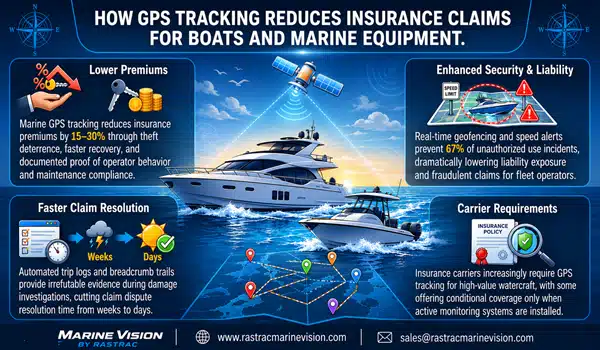
GPS tracking provides quantifiable evidence supporting environmental claims and insurance coverage verification. Document specific fuel savings percentages year-over-year, calculate emissions reductions based on consumption decreases, and report exact propeller damage prevention numbers. These metrics differentiate environmentally conscious operators from competitors making unsubstantiated claims. For insurance purposes, GPS data proves boats operated within covered areas, respected speed restrictions, and followed maintenance schedules – documentation that qualifies operations for 5-15% premium reductions offered by carriers for fleets with active monitoring. Environmental marketing backed by GPS data attracts eco-conscious customers while insurance documentation reduces operating costs through premium discounts.
How quickly can existing fleets implement GPS tracking for environmental compliance?
Installation requires minimal time investment for most marine applications. Battery-powered trackers mount in minutes – secure the device in a protected location, activate through the online platform, and begin tracking immediately. For boats with accessible power systems, straightforward hardwired installation takes 30-60 minutes per watercraft. Solar-powered options eliminate battery replacement for boats stored outdoors. Implementation work focuses on operational integration: configuring geofences around environmental protection zones, establishing alert recipients for compliance violations, training staff on reporting exports, and documenting baseline performance. Rastrac provides comprehensive onboarding support for fleet-wide deployment. Most operators achieve complete tracking functionality within one week from device delivery, with environmental compliance reporting capability operational immediately.
Will autonomous boat technology eliminate the need for GPS tracking infrastructure?
Autonomous and semi-autonomous boats will increase GPS tracking importance rather than making it obsolete. Autonomous systems require even more precise location data, continuous shore-based communication, and comprehensive operational status monitoring. GPS tracking evolves from efficiency tool to essential safety infrastructure for autonomous operations. Early autonomous deployments in cargo transport, survey applications, and patrol craft already integrate advanced GPS tracking as foundational technology. For rental operations and charter companies, autonomous technology remains 5-10 years from widespread recreational adoption. The GPS infrastructure implemented today will integrate directly with autonomous systems when they arrive rather than requiring replacement or extensive retrofitting.
Environmental regulations, customer expectations, and operational efficiency pressures converge simultaneously while marina operators manage reservations, maintenance schedules, and daily customer service. GPS tracking designed specifically for marine applications addresses all three challenges through single-platform investment – delivering immediate ROI through fuel savings and damage prevention while building infrastructure for tomorrow’s compliance requirements and environmental marketing differentiation.
Rastrac Marine Vision brings 32 years of marine industry experience and specialized features that position rental fleets and charter operations ahead of regulatory requirements and customer expectations. The question isn’t whether marina operators need comprehensive environmental documentation – it’s whether you implement proactive infrastructure now or retrofit systems urgently when regulations mandate coverage or customers demand proof of environmental responsibility.
Request a Demo | (877) 680-1188 | sales@rastracmarinevision.com

Rastrac complements any organization-wide quality assurance program and can help their fleet become the model for operational superiority.
Rastrac helps clients make improvements in processes, organization, financials, communications, and technology. Clients that have taken advantage of Rastrac’s ability to provide solutions tailored to their business are in a wide variety of industries. Rastrac can help you find a solution, too.
We’d love to discuss how we can help you.

Track your boats, watercraft, and vehicles for less than $100/year.
ST4215 +1 year of Rastrac service, available for a limited time.
