- 12741 Research Blvd. Suite 500 Austin, TX
- sales@rastracmarinevision.com
- (877) 680-1188
It’s 6:45 PM on a Saturday evening. Your rental pontoon boat was due back at 6:00 PM sharp. The customer isn’t answering their phone. The sun sets in 90 minutes. You have no idea if they’re having the time of their lives on a sandbar, stranded with mechanical trouble, or if your $45,000 watercraft just became another statistic in the $300 million annual boat theft problem.
This scenario plays out hundreds of times daily across marinas, rental operations, and yacht clubs nationwide. Without real-time location data, every late return becomes an expensive guessing game that puts customers at risk, ties up staff resources, and generates liability exposure that keeps operators awake at night.
Marine GPS tracking doesn’t just tell you where your boats are–it transforms how rental operations handle the inevitable late returns, unauthorized route deviations, and genuine emergencies that define the business.
When a fishing boat doesn’t return on schedule, rental operations face a cascading series of operational challenges that compound by the minute. Staff members abandon other customer service tasks to begin the search protocol. The first calls go to the renter’s cell phone, typically met with voicemail or poor reception. Next comes the marina radio check, hoping another boater spotted the overdue center console somewhere on the water.
Without GPS tracking, your team begins the manual search process. Staff walk the docks checking if the speedboat somehow returned without check-in. Someone drives to popular fishing spots hoping to visually locate the bass boat. Another employee calls nearby marinas asking if an unfamiliar bowrider matching your description tied up at their slips. Each minute of uncertainty increases three critical risks: customer safety exposure, theft likelihood, and operational cost escalation.
The financial impact begins immediately. Staff overtime accumulates while normal operations suffer. If you launch a search watercraft, fuel and equipment costs add up quickly. Should the situation escalate to Coast Guard involvement, liability concerns intensify. One Rhode Island rental operator reported spending over $3,000 in search costs for a single overdue pontoon boat that had simply anchored in a cove with no cell service–a situation that GPS tracking would have resolved in under two minutes.
Meanwhile, other customers wait. That prime sunset cruise rental sits empty because you don’t know when or if the overdue pontoon will return. Revenue vanishes while uncertainty spreads across your operation.
Marine GPS tracking eliminates the guesswork that defines traditional late-return scenarios. When a sailboat doesn’t return on schedule, operators with Rastrac Marine Vision systems pull up real-time location data showing the watercraft anchored two miles offshore. The trip history reveals it’s been stationary for 37 minutes. Battery voltage reads normal. Engine hours are within expected range. In under 60 seconds, the crisis becomes a simple courtesy call: “We noticed you’re anchored out past the inlet. Do you need assistance, or are you just enjoying the sunset?”
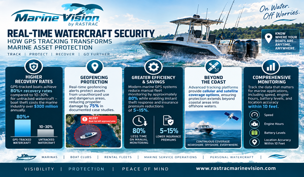
Geofencing creates the first line of defense against late returns and unauthorized use. When you set rental boundaries on a center console, the system monitors compliance automatically. If a customer takes the fishing boat beyond the designated area, you receive instant alerts via text or email. You know the exact location, current speed, and which direction the watercraft is heading before it becomes a serious problem.
Rastrac offers marine tracking solutions matched to different operational environments:
ST4215 Cellular GPS Tracker handles coastal operations where cell coverage remains reliable. This compact, water-resistant device integrates seamlessly with Marine Vision for real-time alerts, trip history, and geofence monitoring on smaller watercraft and jet skis.
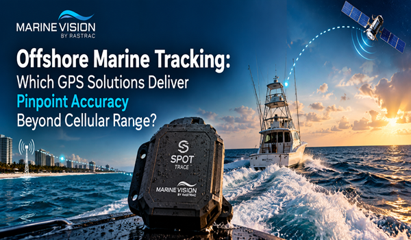
ST9100 Hybrid Satellite/LTE Device automatically switches between cellular and satellite communication based on availability. Perfect for rental operations serving customers who venture offshore beyond cellular range, this tracker maintains contact regardless of distance from shore.
SPOT Trace Satellite Tracker provides pure satellite-based tracking that works completely independent of cell towers, radio frequency, or Wi-Fi. For operations running in remote waters, island destinations, or areas with unreliable cellular coverage, SPOT Trace keeps reporting on or off the grid. The integrated vibration sensor detects movement and sends instant text or email alerts when your pontoon boat, bass boat, or speedboat move–whether it’s supposed to or not. With IPX7 waterproof rating and optional water-mode configuration, SPOT Trace handles marine environments while maintaining contact through its satellite network anywhere with a view of the sky.
All three systems integrate with the Marine Vision platform to provide the unified dashboard view that makes fleet management practical instead of overwhelming.
Real-time alerts cover the scenarios that matter most to rental operations. Movement detection notifies you the moment a bass boat leaves the dock—perfect for catching after-hours unauthorized use. Geofence breaches trigger when customers ignore designated boundaries. Speed monitoring identifies dangerous operation before it causes propeller damage or personal injury. Low battery warnings provide advance notice of potential stranded-customer situations.
One Florida charter operator eliminated 75% of propeller damage in the first season after installing tracking systems on their speedboat fleet. The geofencing prevented customers from entering shallow areas marked as hazards, while speed alerts caught aggressive operation patterns that previously resulted in costly repairs and extended downtime.
Beyond immediate crisis management, GPS tracking builds the operational intelligence that transforms rental businesses from reactive to proactive. Historical trip data reveals patterns invisible to manual observation. You discover that customers renting jet skis on Friday afternoons run late 40% more often than Sunday morning renters. This insight lets you adjust scheduling buffers, pricing incentives, and staffing levels based on actual behavior rather than guesswork.
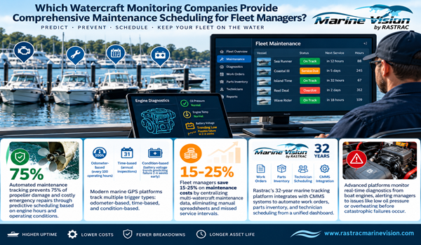
Route analysis identifies which watercraft get used hardest. That pontoon boat you thought was your gentlest rental actually logs twice the engine hours of its fleet mates because customers take it to distant fishing spots. Now you can adjust maintenance schedules based on real usage instead of calendar intervals, preventing breakdowns before they strand customers or trigger expensive tow situations.
The data supports conversations that previously created friction. When a customer disputes late fees, you show them the timestamped track history demonstrating they returned 47 minutes past the deadline. When someone claims they stayed within the designated area, the geofence log provides indisputable evidence they spent 22 minutes in the restricted zone. These aren’t confrontational moments–they’re professional accountability backed by objective data.
Insurance providers recognize the risk reduction that GPS tracking provides. Documented systems for monitoring watercraft location, enforcing boundaries, and responding to emergencies qualify operations for premium discounts ranging from 5-15%. The tracking system essentially pays for itself through insurance savings alone, before considering the operational benefits.
Maintenance optimization represents another compounding advantage. Instead of servicing every bowrider on a fixed calendar schedule, you maintain them based on actual engine hours, trip count, and operating conditions. One marina reduced annual maintenance costs by 23% while simultaneously improving fleet reliability by addressing wear patterns revealed through GPS data that calendar-based schedules missed entirely.
Charter operations use GPS tracking to optimize scheduling and prove service delivery. When customers book a four-hour fishing trip, the trip log provides verifiable proof of time on the water. This transparency eliminates disputes and builds trust that generates repeat bookings and positive reviews.
Yacht clubs managing member-owned sailboats offer GPS tracking as a premium security service. Members receive instant alerts if their watercraft moves outside approved times or areas. The visible deterrent effect reduces theft attempts–criminals target boats without tracking systems rather than risk immediate detection.
Tour operators running multiple pontoon boats track fleet position to coordinate pickups, respond to mechanical issues, and ensure even distribution across popular locations. When one boat develops engine trouble, dispatchers identify the nearest backup watercraft and reroute it within minutes instead of hours. Customers experience seamless service while operations maintain schedule integrity.
Boat dealerships protecting inventory use geofencing around their lots to detect unauthorized movement. Demo boats get tracked during customer test drives to prevent the theft scenarios that plague high-value marine equipment. One Texas dealer recovered a stolen $87,000 center console within six hours of theft thanks to real-time GPS tracking that helped law enforcement intercept it before reaching Mexico.
How quickly can I locate an overdue rental boat with GPS tracking?
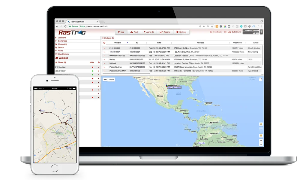
You can view real-time location data within seconds of logging into the Rastrac Marine Vision platform from any internet-connected device. The system displays current position, battery voltage, whether the engine is running, and recent trip history on an interactive map. This immediate access eliminates the hours of manual searching that defines traditional late-return scenarios. If the watercraft operates offshore beyond cellular coverage, the ST9100 hybrid device or SPOT Trace satellite tracker maintains contact, so you never lose visibility regardless of distance from shore.
What’s the difference between cellular and satellite tracking for boats?
Cellular trackers like the ST4215 work excellently in coastal waters where cell towers provide coverage, offering real-time updates and lower service costs. Satellite trackers like SPOT Trace operate independently of cellular networks, making them essential for operations serving remote islands, offshore fishing areas, or regions with unreliable cell service. The ST9100 hybrid device automatically switches between cellular, and satellite based on availability, providing the best of both technologies. Your choice depends on where customers take your watercraft and how far from shore your rental boundaries extend.
What happens if customers disable or tamper with the GPS tracker?
Rastrac devices send immediate power-disconnect alerts the moment external power is interrupted or the device is removed from its mounting location. You receive notification via text or email within minutes of tampering, along with the last known position before disconnection. This rapid alert system enables fast response before thieves can transport the watercraft beyond recovery range. Installation in concealed locations makes unauthorized removal difficult without tools and technical knowledge most casual renters lack.
Can GPS tracking prevent customers from taking boats into dangerous areas?
Yes, through geofencing technology that creates virtual boundaries on the water. When you establish restricted zones around shallow areas, strong currents, or environmentally sensitive regions, the system monitors compliance automatically. If a pontoon boat crosses into a designated hazard area, you receive instant alerts with exact location data so you can contact the customer immediately. One case study documented 75% reduction in propeller damage after implementing geofence enforcement that prevented customers from entering marked shallow areas.
What’s the return on investment for marine GPS tracking in rental operations?
GPS tracking systems typically pay for themselves through multiple channels within the first year. Insurance discounts of 5-15% provide immediate savings on premium costs. Rental operations report 40-60% reduction in damage claims through geofencing enforcement that prevents unauthorized area access. The 80% reduction in manual fleet monitoring time lets staff focus on revenue-generating customer service instead of searching for overdue boats. One marina eliminated $3,000+ per incident in search costs by knowing exact watercraft location instead of launching expensive manual search operations.
Every minute you operate without GPS tracking systems, your rental boats remain invisible between dock departure and return. That exposure creates operational chaos, generates liability risk, and costs you money through inefficiency, damage, and lost revenue opportunities. Marine GPS tracking from Rastrac Marine Vision transforms uncertainty into actionable intelligence that protects your assets, improves customer service, and builds the operational efficiency that separates thriving rental operations from struggling competitors.
Don’t wait for the next overdue watercraft to trigger an expensive search operation. Contact Rastrac today to discover how 32 years of GPS tracking expertise translates into solutions purpose-built for marine rental operations.
Request a Demo | (877) 680-1188 | sales@rastracmarinevision.com

Rastrac complements any organization-wide quality assurance program and can help their fleet become the model for operational superiority.
Rastrac helps clients make improvements in processes, organization, financials, communications, and technology. Clients that have taken advantage of Rastrac’s ability to provide solutions tailored to their business are in a wide variety of industries. Rastrac can help you find a solution, too.
We’d love to discuss how we can help you.
Basic service for your OEM-connected vehicles. No hardware. No installation.
Offer ends November 30, 2026
