- 12741 Research Blvd. Suite 500 Austin, TX
- sales@rastracmarinevision.com
- (877) 680-1188
Last hurricane season, a Florida marina operator watched helplessly as 47 boats broke loose from their moorings during a Category 3 storm. Without real-time tracking, it took nine days to locate all the watercraft – some found 15 miles inland, others capsized in adjacent waterways. The recovery costs exceeded $380,000, and 11 slips remained empty for three months while insurance claims dragged on.
Marina operators face unique challenges during hurricane season. You’re responsible not just for your own assets but for dozens or hundreds of customer boats, jet skis, and yachts worth millions of dollars. When a storm approaches, you need visibility into every watercraft under your care – knowing which owners evacuated their pontoon boats, which sailboats remain at-risk, and exactly where floating assets end up after storm surge.
GPS tracking technology transforms hurricane preparedness from reactive chaos into proactive asset protection.
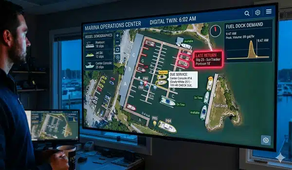
When hurricane warnings trigger evacuation protocols, marina operators need instant visibility across their entire facility. GPS tracking systems provide continuous location updates every 30-60 seconds, allowing you to monitor all watercraft simultaneously from a single dashboard.
During the approach phase, you can:
One Louisiana marina manager describes their experience: “During Hurricane Laura, we watched 83 boats in real-time. We saw exactly when three center consoles broke free at 2:14 AM and sent recovery crews to those GPS coordinates at first light. We recovered all three within four hours.”
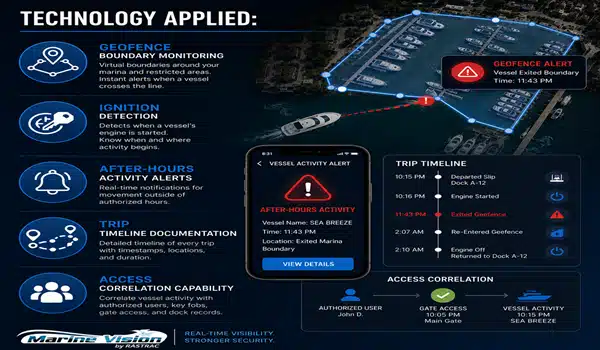
Geofencing creates virtual boundaries around your marina perimeter. When storm surge pushes boats beyond these preset limits, you receive immediate breach notifications with exact coordinates. This eliminates the post-storm search period that typically costs marina operators 5-8 days of recovery time and thousands in lost revenue.
The hours after hurricane impact determine your recovery timeline and insurance outcomes. GPS tracking transforms this critical period from chaotic searching into systematic recovery:
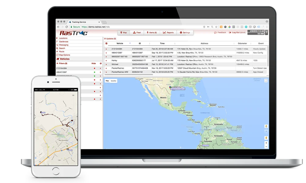
Location Intelligence: Every tracked watercraft appears on your map interface with current coordinates, even if displaced miles from your facility. Recovery crews receive precise navigation instructions instead of conducting grid searches across flood zones.
Movement History: GPS systems log the complete storm timeline, showing when boats broke free, their drift patterns during peak winds, and where they ultimately settled. This documentation proves invaluable for insurance claims and liability questions.
Damage Assessment Prioritization: Your dashboard shows which sailboats remained secure versus which bass boats traveled significant distances. Teams can prioritize recovery efforts based on likely damage severity and location accessibility.
A Texas marina recovered 94% of their displaced watercraft within 48 hours post-Hurricane Harvey by following GPS coordinates directly to stranded boats in parking lots, retention ponds, and flooded neighborhoods. Without tracking, similar-sized marinas in adjacent counties took 11-14 days to locate their full inventory.
Hurricane preparedness begins months before storm season. Installing GPS tracking on marina-owned watercraft and offering it to slip customers creates the foundation for effective storm response:
Fleet-Wide Coverage: Equip all rental jet skis, service boats, courtesy watercraft, and marina vehicles with GPS units. This ensures you can locate and protect your operational assets regardless of storm timing.
Customer Equipment Programs: Offer GPS tracking as a premium service or lease requirement for long-term slip customers. Many boat owners welcome the year-round theft protection and agree to tracking when hurricane season highlights the recovery benefits.
Staff Training Protocols: Designate 2-3 team members as your GPS monitoring specialists. Train them on the dashboard interface, alert interpretation, and coordinate communication with recovery crews. Run quarterly drills where staff practice locating “displaced” watercraft using the system.
Integration with Evacuation Procedures: Update your hurricane checklist to include GPS verification steps. Before storms, staff should confirm all units show active signals and log baseline positions for every tracked watercraft.
Implementation takes 2-4 weeks for a typical 200-slip marina. The Marine Vision by Rastrac system works with existing infrastructure – no special electrical requirements or complex installation. Each GPS unit mounts discreetly and begins transmitting immediately.
When tropical weather systems enter your region’s forecast cone, GPS tracking enables proactive response at every threat level:
72-Hour Watch: Monitor the dashboard every 4-6 hours. Document which customers have visited their boats and verify no unauthorized movement. Send automated reminders to slip renters about securing or evacuating their watercraft.
48-Hour Warning: Shift to 2-hour monitoring intervals. Cross-reference your customer contact list with GPS status. Identify which pontoon boats, sailboats, and yachts remain unmoved and contact those owners directly. Enable movement alerts for all tracked assets.
24-Hour Lockdown: Continuous monitoring begins. One staff member maintains dashboard surveillance while others complete physical facility preparations. Any unexpected watercraft movement triggers immediate investigation. All GPS coordinates and timestamps are logged for post-storm documentation.
During Storm Impact: Remote monitoring from safe locations. Watch for geofence breaches indicating boats breaking free. Log all displacement events with timestamps and coordinates. This real-time intelligence directs post-storm recovery the moment conditions permit.
The technology remains functional through most hurricane conditions. GPS signals transmit through storm activity, and battery-powered units continue operating even when marina shore power fails.
Marina operators carry substantial liability for customer property under their care. GPS tracking strengthens your position across multiple operational areas:
Insurance Premium Reductions: Many marine insurance carriers offer 10-15% policy discounts for marinas with comprehensive GPS tracking. The documented asset protection and rapid recovery capabilities reduce insurer risk and your annual premiums.
Claims Documentation: GPS movement logs provide irrefutable evidence of when watercraft left secured positions, their storm-period trajectories, and final displacement locations. This documentation accelerates claims processing by 40% compared to marinas relying on witness statements and post-storm surveys.
Customer Confidence: Slip renters increasingly expect modern asset protection. Marketing your GPS tracking capabilities attracts higher-value yacht owners and long-term customers willing to pay premium rates for facilities that prioritize their watercraft security.
Legal Protection: If disputes arise about whether your marina took reasonable precautions, GPS logs demonstrate proactive monitoring and documentation of storm events. This evidence supports your defense in liability cases.
One South Carolina marina operator reports: “After we installed GPS tracking across our facility, our insurance carrier reduced our policy premium by 12%. The cost savings paid for the entire system in 18 months, and we haven’t even factored in the recovery time benefits and customer retention improvements.”
Q: How does GPS tracking continue working when marina power fails during hurricanes?
A: GPS units operate on internal batteries that last 30-90 days depending on the model. They don’t rely on marina shore power or internet connectivity. The units transmit via cellular networks, which typically restore within 12-24 hours post-storm. Even if cellular service temporarily drops during peak hurricane conditions, the GPS logs all movement data and uploads it automatically when connectivity returns.
Q: Can GPS tracking help during the mandatory marina evacuation that local authorities sometimes order?
A: Absolutely. When authorities require complete facility evacuation, marina operators traditionally had zero visibility into their property until re-entry permission was granted days later. With GPS tracking from Marine Vision by Rastrac, you maintain remote monitoring capability from evacuation locations. You’ll know immediately if watercraft break loose, if unauthorized persons enter your facility, or if flooding reaches critical levels based on asset displacement patterns. This intelligence helps you communicate accurately with insurance companies, customers, and authorities about facility status.
Q: What’s the typical ROI timeline for a marina implementing GPS tracking specifically for hurricane preparedness?
A: Most marinas see positive ROI within one major storm event or 18-24 months of operational use. Consider that locating a single displaced yacht without GPS averages 40-80 person-hours of search effort. GPS reduces this to 2-4 hours maximum. For a 200-slip facility, avoiding just three days of post-hurricane closure due to faster recovery generates $15,000-30,000 in revenue protection. The insurance premium reductions (typically 10-15%) provide ongoing annual savings that accumulate over time. Marinas in high-activity hurricane zones often achieve ROI in a single season.
Q: Do customers object to having GPS tracking on their boats while stored at our marina?
A: Customer acceptance is typically 85-90% when you frame GPS tracking as a premium security service rather than surveillance. Boat owners value the theft protection, recovery assistance, and insurance documentation benefits. Many appreciate receiving movement alerts if their watercraft leaves the marina without authorization. Present it during slip agreements as an asset protection service that benefits both the marina and the owner. Some operators make GPS tracking optional for premium slips while requiring it for high-value yachts and long-term rentals.
Q: How quickly can we get GPS tracking operational before this year’s hurricane season?
A: Marine Vision can deploy GPS tracking for a typical marina in 10-15 business days from order to full operation. This includes hardware delivery, installation on your priority watercraft, staff training on the monitoring dashboard, and geofence configuration around your facility. For urgent pre-season installations, expedited deployment is available. The system requires no special infrastructure – units install quickly with basic tools and begin transmitting immediately. You’ll have full monitoring capability before the peak storm months.
Hurricane preparedness can’t wait until tropical systems enter the forecast cone. Marina operators who implement GPS tracking before storm season gain months of operational benefits while building the infrastructure they’ll need during the next major weather event.
Every day without tracking is another day of vulnerability for your watercraft inventory, customer property, and revenue-generating slips. The next Category 3 or 4 hurricane will test your facility’s resilience and your ability to recover quickly.
Request a Demo | (877) 680-1188 | sales@rastracmarinevision.com

Rastrac complements any organization-wide quality assurance program and can help their fleet become the model for operational superiority.
Rastrac helps clients make improvements in processes, organization, financials, communications, and technology. Clients that have taken advantage of Rastrac’s ability to provide solutions tailored to their business are in a wide variety of industries. Rastrac can help you find a solution, too.
We’d love to discuss how we can help you.

No hardware, no installation.
Activation fee waived for every device.
Save 20% on service for six months.
