- 12741 Research Blvd. Suite 500 Austin, TX
- sales@rastracmarinevision.com
- (877) 680-1188
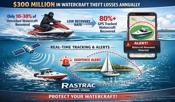
Marina operators face mounting pressure to protect valuable assets, minimize liability, and demonstrate safety compliance to regulators and insurance carriers. One collision in shallow water, one speedboat straying into a dangerous current zone, or one unauthorized rental outside designated boundaries can cost thousands in repairs and legal exposure. Traditional manual monitoring fails: dispatchers can’t watch fifty boats simultaneously, GPS alone doesn’t prevent entry into hazard zones, and paper logs don’t survive insurance audits.
Geofencing: the technology that creates invisible digital boundaries on a map solves this problem. When a yacht, pontoon boat, or jet ski crosses a boundary you’ve defined, the system instantly alerts marina staff via text, email, or in-app notification. More importantly, geofencing documentation proves to insurers and regulators that your facility actively prevented unsafe operations. Rastrac’s Marine Vision platform takes this further, offering polygon-shaped boundaries around reefs, corridor-based safeguards along approved channels, and circular zones that protect shallow-draft areas. This post explores how leading marine GPS tracking providers use geofencing to transform marina safety, reduce damage claims, and ensure regulatory compliance.
Marina safety hinges on preventing boats from entering areas where accidents are most likely. A center console drifting into a shallow bay at night, a speedboat racing through a no-wake zone, or a fishing boat straying into a restricted current area, each scenario creates liability and insurance exposure. Geofencing doesn’t replace human oversight, but it enforces boundaries automatically and creates an audit trail that proves due diligence.
Rastrac’s Marine Vision platform lets you define three types of geofences:
When a boat enters or exits any geofence, marina staff receive an instant alert. The system logs the timestamp, boat ID, geofence name, and violation type – documentation that insurers and Coast Guard auditors specifically request.
Numbers matter in marina operations. Insurance companies demand proof that you’ve taken reasonable precautions to prevent foreseeable accidents. Rastrac’s documented results provide that proof.
| Metric | Improvement |
| Propeller damage reduction | 75% in first season |
| Downtime reduction | Substantial, increasing overall revenue |
| Manual fleet monitoring reduction | 80% decrease in operator workload |
A rental operation using Marine Vision reported that in the first boating season after device installation, propeller damage -the costliest recurring expense in marina maintenance-dropped 75 percent. Staff stopped wasting hours responding to groundings in shallow zones because boats never entered them in the first place. Downtime plummeted: fewer boats in dry dock meant more rental inventory available and higher revenue per season.
Rental operations using geofencing to enforce rental boundaries report 40-60% reduction in damage claims. The ROI appears in the first month: one prevented propeller strike pays for an entire year of GPS tracking and geofencing service.
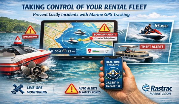
Large marinas with hundreds of boats in various slips, mooring fields, and dry-storage racks face a unique problem: different boat types need different rules. A pontoon boat should never leave its shallow-draft zone. A sailboat on a mooring should trigger alerts if it drifts beyond secure anchor radius. A center console in the active charter fleet should stay within designated offshore corridors.
Rastrac’s geofence-within-geofence capability solves this. You can layer multiple geofences: a master boundary for the entire marina, sub-zones for rental vs. owner vessels, hazard zones for each boat type, and speed-restricted areas around fuel docks and launch ramps. Each geofence triggers independent alerts.
Marina Safety Geofence Layers:
This granular approach transforms geofencing from a simple “did the boat leave?” tool into a dynamic safety system that adapts to how your specific marina operates.
Marina operators answer to multiple authorities: local harbormaster offices, Coast Guard vessel traffic systems, insurance carriers, and increasingly, environmental agencies protecting water quality and marine life. Every interaction carries liability implications.
Geofencing documentation answers the three questions regulators always ask:
Insurance carriers specifically ask about geofencing. A marina that demonstrates active prevention not just reactionary incident response qualifies for premium discounts of 5-15 percent. Rastrac’s Marine Vision platform generates automated reports showing geofence breaches, prevented violations, and total fleet monitoring uptime. These reports slot directly into insurance applications and regulatory filings.
Compliance Documentation Geofencing Provides:
For charter and tour operators, geofencing eliminates disputes. A customer claims they were charged unfairly for operating outside boundaries? Pull the geofence log. A guide claims a boat malfunctioned outside the approved zone? Documentation proves whether the boat stayed within designated waters. These records become gold in liability disputes.
Rastrac’s marine-specific hardware integrates seamlessly with geofencing. The ST4215 water-resistant tracker mounts easily on smaller sailboats, fishing boats, and personal watercraft ideal for rental fleets where dozens of units see frequent installation and removal. It maintains 10-foot positional accuracy in marine environments, precise enough to detect entry into geofenced zones before dangerous situations escalate.
For offshore operations or charter boats that venture beyond cellular range, the ST9100 hybrid LTE/satellite device automatically switches from cellular to satellite communication, ensuring continuous geofence monitoring even miles from shore. Installation requires no complex wiring, battery-powered mounting works on boats without accessible power systems.
The system reduces manual fleet monitoring by approximately 80 percent, allowing one dispatcher to oversee operations that previously required constant visual contact. Staff can focus on customer service and safety response rather than binocular-based boat tracking.
Q: How quickly does geofencing trigger an alert when a boat enters a restricted zone?
A: Rastrac’s Marine Vision platform generates instant notifications via email, SMS, or in-app push when a boat crosses any geofence boundary. The system processes position updates frequently enough (typically every 2-10 minutes depending on configuration) to catch boundary breaches in real-time. For critical safety zones, Marina Vision supports emergency alarm activation directly on the boat.
Q: Can we set up different geofences for different boat types?
A: Yes. You can create unlimited geofences and assign different alert rules to each. A rental pontoon boat and an owner’s sailboat can occupy the same geographic area but trigger completely different notifications. Geofence-within-geofence capability allows you to stack rules: a boat might be permitted in Zone A, but triggering an alert if it enters Zone B within Zone A.
Q: What happens if we need to change our geofence boundaries?
A: Geofence modification takes seconds in the Rastrac dashboard. You can draw new boundaries, adjust radius, add/remove polygon points, or delete zones entirely. Changes take effect immediately. However, remember that Rastrac applies geofences to data from the creation date forward, historical data cannot be retroactively analyzed against old boundaries.
Q: Does geofencing work if the boat loses cellular signal?
A: Rastrac devices store position data locally when out of service and sync automatically when signal returns. However, real-time geofence alerts require continuous connectivity. For offshore operations, the ST9100 hybrid satellite/LTE device ensures geofence coverage beyond cellular range.
Q: What documentation do insurance carriers want to see?
A: Insurers request geofence violation reports, entry/exit logs, speed-in-zone monitoring data, and maintenance interval compliance – all generated automatically by Rastrac’s Marine Vision reporting system. These become part of your regulatory file and support premium-discount applications.
Geofencing transforms marina operations from reactive incident management into proactive risk prevention. You get documented proof of safety compliance, reduced liability exposure, lower insurance premiums, and team members freed from constant manual monitoring to focus on customer service. Rastrac’s Marine Vision platform delivers all of this with water-resistant hardware, real-time alerts, and reports that satisfy regulators and insurers instantly.
Stop waiting for the next propeller strike or boundary violation to prove your commitment to safety. Start building your geofence network today.
Request a Demo | Purchase Devices | (877) 680-1188 | sales@rastracmarinevision.com
Rastrac complements any organization-wide quality assurance program and can help their fleet become the model for operational superiority.
Rastrac helps clients make improvements in processes, organization, financials, communications, and technology. Clients that have taken advantage of Rastrac’s ability to provide solutions tailored to their business are in a wide variety of industries. Rastrac can help you find a solution, too.
We’d love to discuss how we can help you.