- 12741 Research Blvd. Suite 500 Austin, TX
- sales@rastracmarinevision.com
- (877) 680-1188
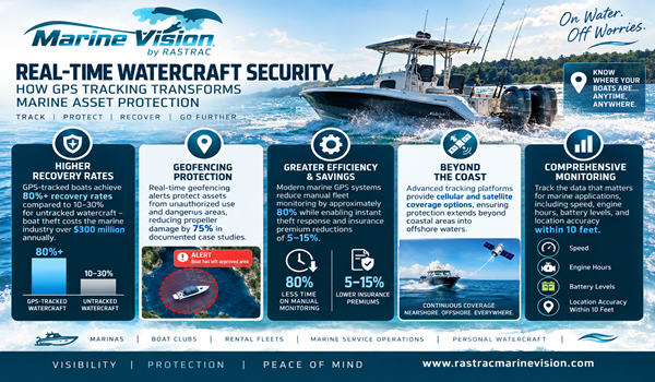
The moment your fishing boat crosses the 20-mile mark offshore, your cellular-based tracker stops reporting. Your expensive yacht sits somewhere in open water with zero visibility. Charter captains lose contact with their fleet. This communications blackout isn’t just inconvenient–it’s dangerous and costly. Boat theft costs the marine industry over $300 million annually, and without continuous tracking, recovery becomes nearly impossible. Modern marine GPS tracking solves this problem by combining cellular networks with satellite technology. The right system maintains pinpoint accuracy whether your watercraft operates three miles from shore or 300 miles offshore, delivering the real-time location data you need for fleet management, theft recovery, and emergency response.
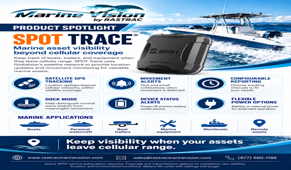
For Marine Vision customers, this is where SPOT Trace adds a critical capability. SPOT Trace is designed for satellite-based asset tracking, extending location visibility to boats and marine assets operating where cellular service is weak or unavailable. It gives fleet managers a practical satellite option for offshore operations without making every asset dependent on satellite service.
Most GPS tracking devices rely exclusively on cellular networks–LTE Cat-M1, 4G, or older 3G technology. These systems work perfectly for recreational boating near coastlines. A pontoon boat cruising a lake, a jet ski operating within five miles of shore, or a bass boat fishing coastal waters maintains constant cellular connectivity. Your tracking dashboard updates every 30 seconds with precise coordinates.
But cellular towers have physical limitations. LTE signals typically reach 10-20 miles offshore under ideal conditions. Weather, wave height, and antenna placement affect range. Once your speedboat crosses that invisible boundary, the cellular modem loses its connection. Your tracking system goes dark. The last known position might be 15 miles behind the boat’s current location.
This creates serious operational gaps. Charter operators lose visibility into their sailboat fleet during offshore excursions. Commercial fishing operations can’t monitor their boats during multi-day trips. Yacht owners have zero theft protection once watercraft leave coastal waters. Emergency responders can’t locate boats in distress beyond cellular range.
The ST4215 water-resistant tracker demonstrates these limitations clearly. This compact cellular GPS device excels at coastal tracking–it’s rugged, affordable, and perfectly sized for smaller watercraft like jet skis and center consoles. Installation takes minutes without complex wiring. For operations within cellular coverage, it’s an excellent solution. But take that same device 25 miles offshore, and reporting stops entirely.
For watercraft that travel beyond cellular coverage, Marine Vision offers SPOT Trace as a dedicated satellite tracking solution. Rather than depending on shore-based cellular towers, SPOT Trace communicates through a satellite network, making it well suited for offshore boats and other valuable marine assets that need location visibility where LTE service is unavailable.
In practice, SPOT Trace can remain with the asset as it moves from the marina into offshore waters. Satellite communication does not depend on a nearby cell tower, making SPOT Trace especially valuable for fishing boats, cruising vessels, trailers, equipment, and other assets whose routes or storage locations can extend beyond dependable cellular service.
Satellite networks operate differently than cellular. Instead of land-based towers, signals bounce between satellites in low-Earth or geostationary orbit and ground stations worldwide. This creates truly global coverage–your tracking works in the middle of the Pacific Ocean, the Gulf of America, the Atlantic, or anywhere else your watercraft travels.
Satellite service typically costs more than cellular-only tracking, but it addresses a different operational need: visibility where cellular coverage cannot be relied upon. For offshore operators, SPOT Trace can add an important layer of asset awareness and theft protection when boats or equipment travel into remote areas.
SPOT Trace uses GPS positioning with satellite communications to report asset location beyond cellular range. Reporting intervals and available features differ from high-frequency cellular tracking, so Marine Vision can help determine whether SPOT Trace, a cellular device, or a combination of technologies best matches the operating profile.
Generic consumer GPS trackers quote accuracy in hundreds of feet. That’s acceptable for highway trucking but inadequate for marine operations where boats operate in close quarters near docks, navigate narrow channels, or need to return to precise fishing coordinates.
Rastrac’s Marine Vision platform implements several accuracy improvements. Multi-constellation GNSS support means devices track satellites from GPS (USA), GLONASS (Russia), Galileo (EU), and BeiDou (China) simultaneously. More satellites visible = better position calculation. Open ocean provides ideal conditions–no buildings or terrain blocking satellite signals–which enhances accuracy beyond land-based applications.
Position update frequency affects perceived accuracy. A device reporting every 5 minutes might show a wakeboard boat 2 miles from its actual position if it traveled quickly between updates. High-frequency reporting–every 30 seconds or every minute–creates a breadcrumb trail that accurately represents the boat’s path. The Rastrac platform uses intelligent tracking that adjusts reporting based on movement, sending more frequent updates when watercraft accelerate or change direction.
Real-world accuracy validation happens every time a captain navigates to saved coordinates. Charter operators set waypoints for popular fishing spots using GPS coordinates from their tracking system. When they return weeks later, the coordinates put them within feet of the exact location. This practical accuracy proves the system’s reliability better than any specification sheet.
Accuracy also depends on proper antenna placement. Marine GPS antennas should mount with clear sky view, away from metal structures that cause signal reflections. The antenna should be horizontal (not tilted) and weatherproofed against saltwater exposure. Many accuracy complaints trace back to poor installation–an antenna mounted inside a fiberglass console or blocked by a hardtop structure can’t receive clean satellite signals.
Match your tracking solution to your operational profile. Coastal operations within 15 miles of shore work perfectly with cellular-only trackers like the ST4215. Pontoon boat rentals, jet ski operations, wakeboard boats, and nearshore fishing boats rarely need satellite coverage. Cellular systems cost less, install easily, and provide frequent position updates through LTE networks. Insurance companies offer 5-15% discounts on watercraft with active GPS tracking–the premium savings alone can offset the hardware cost.
Mixed coastal-offshore operations can benefit from using Marine Vision cellular tracking for high-frequency near-shore visibility while equipping offshore or remote assets with SPOT Trace. Charter fishing boats, cruising vessels, trailers, and equipment that move outside reliable LTE coverage can retain satellite-based location visibility without depending on a cellular tower.
Remote offshore operations are where SPOT Trace becomes especially important in the Marine Vision portfolio. Long-range cruising boats, commercial fishing vessels, and other marine assets that routinely travel or remain beyond cellular coverage can use SPOT Trace as a satellite-based tracking option. Marine Vision can also help operators determine when a cellular, satellite, or blended fleet deployment makes the most sense.
Fleet size influences decision-making too. A marina with 50 rental boats needs cost-effective cellular tracking for each unit. The volume makes cellular-only systems economically sensible. A charter operation with three offshore fishing boats might justify hybrid trackers for better coverage. Calculate total cost of ownership–hardware, monthly service fees, and potential insurance savings–across your entire fleet before choosing.
Battery-powered options like the BeSol solar tracker work for boats stored outdoors or watercraft without accessible power systems. Solar recharging eliminates battery replacement, though position reporting frequency may be lower to preserve power. Hardwired installations provide continuous power for high-frequency tracking but require straightforward electrical connections to the boat’s power system.
Q: How can I track my boat or marine asset after it leaves cellular coverage?
A: Marine Vision offers SPOT Trace for satellite-based asset tracking beyond cellular range. Because SPOT Trace communicates through a satellite network rather than relying on nearby LTE towers, it can provide location visibility in offshore and remote areas where cellular-only trackers stop communicating. For fleets operating both near shore and offshore, Marine Vision can recommend a mix of cellular and SPOT Trace devices based on each asset’s operating pattern.
Q: Can I track multiple watercraft from one dashboard?
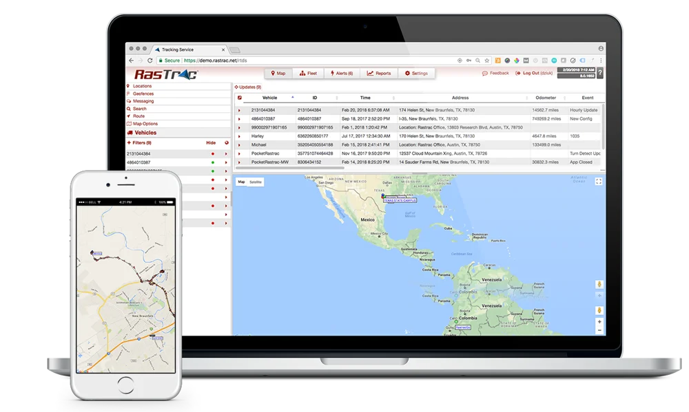
A: Yes. The Marine Vision platform manages unlimited watercraft from a single dashboard. You’ll see real-time positions for your entire fleet–fishing boats, pontoon boats, jet skis, sailboats, or any combination–on one map interface. Create geofences around marinas or restricted areas, receive alerts when specific boats exceed speed limits, and generate reports showing each watercraft’s usage patterns. Multi-watercraft visibility reduces manual monitoring by approximately 80%.
Q: What accuracy should I expect from marine GPS tracking?
A: Standard GPS provides ±100 meters accuracy, but marine applications using Rastrac can achieve accuracy within 10 feet through specialized configurations. Accuracy depends on satellite visibility (excellent over open water), antenna placement, update frequency, and GPS constellation usage. Hybrid devices maintain consistent accuracy whether operating via cellular or satellite networks. Proper antenna installation with clear sky view maximizes positioning precision.
Q: Will GPS tracking help recover my boat if it’s stolen?
A: GPS tracking dramatically improves recovery odds. Boats without tracking have 10-30% recovery rates, while GPS-tracked watercraft achieve 80%+ recovery rates. Geofencing alerts notify you immediately if your yacht leaves its approved location. Real-time tracking guides law enforcement directly to the stolen boat’s current position. The visible deterrent effect–“GPS Tracked” decals on your speedboat–prevents many thefts before they occur. Boat theft costs the industry $300M+ annually; tracking is proven protection.
Q: How difficult is marine GPS tracker installation?
A: Most marine trackers require no complex wiring or professional installation. Battery-powered devices like the BeSol mount with screws or zip ties and operate immediately. Cellular trackers typically use simple 2-3 wire connections: power, ground, and optional ignition detection. Hardwired installations on boats with accessible power are straightforward and take minimal time. The ST4215’s compact form factor fits easily on smaller watercraft. Rastrac provides installation guides and phone support to walk you through the process.
Your watercraft and marine assets may travel far beyond the reach of cellular towers. Marine Vision combines its marine tracking platform and decades of GPS experience with SPOT Trace satellite tracking to extend asset visibility into offshore and remote areas. Whether you manage charter boats, fishing vessels, cruising watercraft, trailers, or valuable equipment, Marine Vision can build a tracking approach around where those assets actually operate.
Request a Demo | (877) 680-1188 | sales@rastracmarinevision.com

Rastrac complements any organization-wide quality assurance program and can help their fleet become the model for operational superiority.
Rastrac helps clients make improvements in processes, organization, financials, communications, and technology. Clients that have taken advantage of Rastrac’s ability to provide solutions tailored to their business are in a wide variety of industries. Rastrac can help you find a solution, too.
We’d love to discuss how we can help you.

Basic service for your OEM-connected vehicles. No hardware. No installation.
Offer ends November 30, 2026
