- 12741 Research Blvd. Suite 500 Austin, TX
- sales@rastracmarinevision.com
- (877) 680-1188
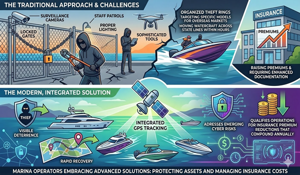
Summer is peak season for watercraft rentals. It is also when liability skyrockets. Between Memorial Day and Labor Day, rental operators face a collision of challenges: renters pushing jet skis to dangerous speeds, propellers hitting underwater obstacles, fuel bills inflating, and equipment vanishing. Without real-time visibility into where your fleet is, and what customers are doing, you are managing blind.
The stakes are measurable. A single propeller strike can cost $2,500–$5,000 in repairs. A stolen pontoon boat becomes a total loss. An uninsured accident triggers liability claims. Rastrac Marine Vision exists to solve exactly these problems. This guide walks you through the five biggest summer concerns for watercraft rental companies and how GPS tracking transforms each one from a cost center into a competitive advantage.
Propeller strikes are the costliest rental claim. A renter navigates shallow water, hits a sandbar, and, crunch, you are replacing a propeller, which runs $500–$2,500 depending on the boat. Scale that across a 20-unit fleet across a summer season, and you are looking at $12,000–$30,000 in avoidable damage.
Rastrac case studies show a 75% reduction in propeller damage in the first boating season after installation. How? Speed monitoring combined with geofencing for shallow-water zones. When a renter accelerates beyond safe limits or ventures into a no-go area marked on the map, fleet managers receive instant alerts. They can contact the renter immediately, preventing the strike before it happens.
This is not theoretical. Rental operators using Rastrac report:
The ski boat or wakeboard boat becomes a trackable asset with built-in accountability. Renters respect the system. Managers sleep better. The math is simple: Rastrac investment saves $12,000–$30,000 in propeller damage alone.
Boat theft costs the marine industry $300M+ annually. Larger numbers hide the real pain: boats without GPS tracking are recovered only 10–30% of the time. GPS-tracked boats recover at 80%+ rates.
Summer amplifies theft risk. Higher volumes of renters, longer hours of operation, busy ramps and docks all create distraction and opportunity. A pontoon boat borrowed for the weekend and never returned. A personal watercraft stolen from a dock during peak hours. These scenarios destroy rental businesses.
Rastrac Marine Vision gives renters no anonymity. Every boat is pinpointed to within 10 feet. If a jet ski is moved outside the rental zone or after business hours, an alarm triggers. The moment a WaveRunner disappears, the operator has a live location, not a “missing” placeholder. Recovery teams and law enforcement can act immediately.
Insurance companies recognize this advantage: GPS-tracked watercraft qualify for 5–15% premium discounts. That discount alone offsets the tracking subscription within 6–12 months. More importantly, it means your insurance remains affordable even as claims drop.
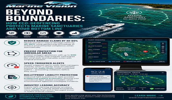
Not all renters intend to misbehave. Many simply don’t understand where they can safely operate. A renter takes a wakeboard boat beyond the approved lake zone into swift currents. Another jet ski user drifts into a no-wake area that damages sensitive shoreline. These boundary violations create liability, damage claims, and conflict with customers.
Geofencing eliminates ambiguity. Define the approved operating zone on a digital map. When a watercraft leaves that zone, the renter receives an automatic alert via text or app notification. They correct course. No damage. No escalation.
Rental operations using geofencing report:
A pontoon boat with geofencing becomes self-policing. The renter is empowered to make safe decisions. The operator retains control without micromanagement.
Summer brings peak utilization and peak fuel waste. Idling at the dock, inefficient ramp routes, long trips with poor planning – these add up. Charter operators and rental fleets report 15–25% potential fuel cost savings through real-time optimization and idle monitoring.
Rastrac tracks:
Idle monitoring is particularly powerful. A center console left running at a busy dock burns fuel with zero revenue. Rastrac data surfaces these patterns. You adjust procedures: dock attendants turn off engines between rentals, renters understand fuel-idle penalties, managers schedule dock time to minimize downtime.
The ski boat that idles for 2 hours per week wastes approximately one tank of fuel monthly. Across a 20-boat fleet, that’s 20+ tanks per month, thousands of dollars annually. Visible tracking makes this waste obvious and eliminates it.
Insurance underwriters have become strict about recreational watercraft. They ask: How do you monitor operator behavior? How do you prevent unauthorized use? How do you enforce safety zones? Without GPS data, the answer is “we hope and pray.” With it, you have proof.
Rastrac devices enable:
This data becomes your defense. When an underwriter questions your safety practices, you show real numbers. When a liability claim arises, location and speed data clarify what happened. When you renew your policy, you present lower claims and better risk profile, justifying those 5–15% insurance discounts.
Summer is also when regulatory agencies check in. Geofencing ensures compliance with protected-water restrictions. Speed data proves you are enforcing safe speeds. Engine-hours logs verify maintenance is happening on schedule. Compliance becomes automatic, not manual.
FAQ
Q: How much does Rastrac Marine Vision cost for a rental fleet?
A: Pricing is device-based and scales with fleet size. ROI is immediate through damage reduction (75% fewer propeller strikes), theft recovery (80%+ recovery rates), and insurance discounts (5–15%). Contact Rastrac sales for a specific quote based on your fleet composition.
Q: Can renters disable the tracker or turn it off?
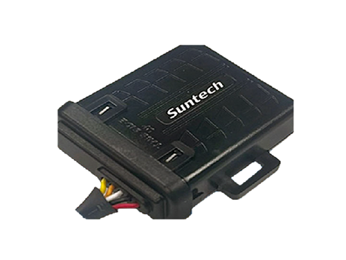
A: Rastrac devices are hardwired (or solar-powered with no accessible power button) and secured to the boat. Renters cannot disable them. The platform includes alerts if a device loses signal, so any tampering is immediately visible to managers.
Q: Which Rastrac devices are best for jet skis and small watercraft?
A: The ST4215 is ideal for smaller watercraft and coastal operations—water-resistant, compact, and reliable. For offshore or remote areas beyond cellular coverage, the ST9100 hybrid LTE/satellite device ensures continuous tracking regardless of location. Rastrac’s sales team can recommend the right fit for your specific fleet mix.
Q: How does geofencing actually work during a rental?
A: You define the approved operating zone on the Rastrac platform map. When a renter takes the boat outside that zone, the system sends an automatic text or push notification to their phone and alerts to your management dashboard. The renter sees a message like “You’re outside the approved operating area, please return to the zone.” No signal jamming, no false alarms, just real-time guidance that keeps them safe and compliant.
The rental season is here. Equipment will fail, renters will push boundaries, and fuel costs will climb. But you don’t have to face these challenges blind. Rastrac Marine Vision gives you complete real-time visibility into your fleet, prevents costly damage before it happens, deters theft, and pays for itself through insurance savings and operational efficiency within months.
Request a Demo | Purchase Devices | (877) 680-1188 | sales@rastracmarinevision.com
Rastrac complements any organization-wide quality assurance program and can help their fleet become the model for operational superiority.
Rastrac helps clients make improvements in processes, organization, financials, communications, and technology. Clients that have taken advantage of Rastrac’s ability to provide solutions tailored to their business are in a wide variety of industries. Rastrac can help you find a solution, too.
We’d love to discuss how we can help you.
Track your boats, watercraft, and vehicles for less than $100/year.
ST4215 +1 year of Rastrac service, available for a limited time.