" Rastrac offers historical heat mapping and depth tracking tools that allow powerboaters to better plan routes, track water level trends, and mark potential hazards. "
Lake Heat Maps & Depth Tracking: A Must-Have for Recreational Powerboaters
For recreational powerboaters, lake levels and depth variations are critical for safety, performance, and navigation. While water levels fluctuate seasonally, understanding historical depth trends can help boaters avoid hazards, plan efficient routes, and make the most of their time on the water.
How Historical Lake Heat Maps & Depth Tracking Benefit Powerboaters
Avoiding Shallow Areas & Navigational Hazards
Water levels change over time, and historical depth data helps boaters understand which areas may become too shallow during certain seasons.
Submerged hazards like sandbars, fallen trees, and rocks can be marked by users on their maps, creating a customized navigation guide.
Optimizing Speed & Performance
Powerboaters can reference historical depth maps to locate consistently deeper channels that allow for higher speeds and smoother rides.
Tracking past depth trends helps boaters identify safe areas for cruising without the risk of propeller or hull damage.
Enhancing Wakeboarding, Waterskiing & Tubing
Certain parts of a lake may historically maintain stable depths, making them ideal for water sports.
Users can mark their preferred recreation spots on their maps for easy reference and safer boating.
Planning Routes & Understanding Seasonal Water Level Changes
While automatic lake level monitoring is not available everywhere, historical data can help predict trends in areas where levels fluctuate.
How Rastrac Helps Powerboaters Navigate with Confidence
Rastrac offers historical heat mapping and depth tracking tools that allow powerboaters to better plan routes, track water level trends, and mark potential hazards.
Historical Depth & Water Level Trends – Use past data to plan the best routes and avoid seasonal shallows.
Custom Location Marking – Identify submerged hazards, docks, and recreation spots on your personalized map.
Lake Level Monitoring – Where data is available, customers can access historical lake level data to assist with trip planning.
GPS-Based Mapping & Navigation Support – Get better situational awareness with location tracking and user-generated insights.
By utilizing historical lake data and customizable mapping tools, Rastrac helps powerboaters enjoy a safer, smoother, and more predictable experience on the water.
Rastrac complements any organization-wide quality assurance program and can help their fleet become the model for operational superiority.
Rastrac helps clients make improvements in processes, organization, financials, communications, and technology. Clients that have taken advantage of Rastrac’s ability to provide solutions tailored to their business are in a wide variety of industries. Rastrac can help you find a solution, too.
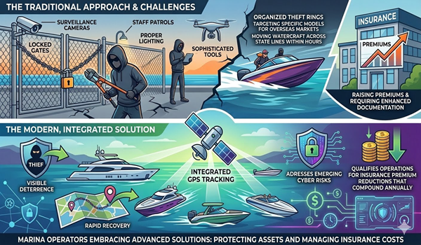
From cyber risks to daily dock management, modern marine operations require advanced solutions. Discover how investing in dedicated marine GPS tracking protects your assets, lowers insurance premiums, and builds the infrastructure needed for future autonomous technology.
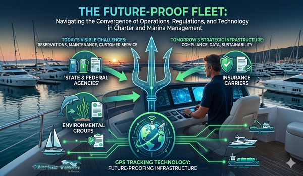
From regulations to daily maintenance, marina management is increasingly complex. Discover how a single marine GPS tracking platform can streamline your operations, protect your bottom line, and elevate your environmental marketing.
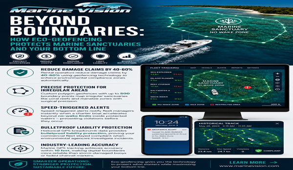
Protect marine habitats and your bottom line. Discover how Rastrac Marine Vision uses custom polygon eco-geofencing and speed alerts to keep fleets compliant with wildlife laws.