- 12741 Research Blvd. Suite 500 Austin, TX
- sales@rastracmarinevision.com
- (877) 680-1188
For boat rental operators and marina managers, peak season is a high-stakes race. Every hour a watercraft spends on the water represents revenue. Conversely, every hour a boat spends in the repair shop represents lost profit, frustrated customers, and mounting maintenance bills.
The biggest threat to your summer bottom line isn’t a lack of bookings, it is hidden just inches beneath the surface of the water.
Sandbars, rocky shoals, and shallow reefs can destroy a fiberglass hull or a stainless-steel propeller in seconds. While you can instruct renters to watch their depth gauges and avoid hazards, relying entirely on a novice boater’s navigation skills is a massive financial gamble.
Here is how fleet managers are using Rastrac Marine Vision as a digital “Virtual Anchor” to stop shallow-water damage before it ever happens.
When a renter accidentally drifts into a shallow cove or clips a submerged sandbar, the immediate damage to the propeller is often just the tip of the iceberg. Shallow-water impacts frequently lead to:
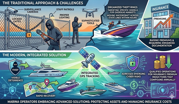
Traditionally, operators have tried to mitigate this risk using paper maps, verbal warnings during check-out, or basic onboard GPS units. However, when customers get distracted by family, friends, or the open water, those warnings are easily forgotten.
Rastrac Marine Vision changes the paradigm from reactive repairs to proactive prevention. Instead of waiting for a customer to call the marina to report a damaged motor, the platform acts as a remote safety supervisor for your entire fleet.
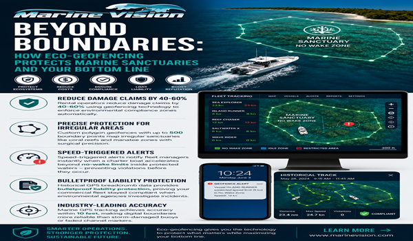
The system relies on highly precise, live GPS tracking tailored specifically for marine environments. By utilizing the platform’s advanced geofencing capabilities, fleet managers can map out custom digital boundaries directly on top of local waterways.
Before your boats ever leave the dock, you can draw virtual boundaries around known hazards on your digital dashboard. Whether it is a seasonal sandbar, a rocky shoreline, or a federally protected wildlife area, you define the exact coordinates where your boats do not belong.
You cannot watch a tracking map every second of the day, and you don’t have to. The moment a rental vessel crosses the threshold into a restricted geofence, the system triggers an immediate, automated alert. Marina managers receive a text message or desktop notification identifying the specific boat and its exact location.
Because the tracking is real-time, operators receive the alert as the boat enters the buffer zone-long before it reaches the critical depth where the hull or propeller would strike the bottom. This window allows the marina staff to call the renter via radio or cellphone, instruct them to shift into neutral, and guide them back to safe water.
Managing a marine fleet always involves variables you cannot control, like the weather or customer boating experience. However, you can control how your fleet responds to environmental hazards.
Deploying Rastrac Marine Vision gives your marina a massive competitive advantage. You protect your valuable capital assets, keep your vessels in rotation during your peak earning months, and provide a seamless, stress-free experience for your customers.
Stop letting hidden hazards dictate your season’s profitability.
Ready to see the Virtual Anchor in action?
Contact the team at Rastrac today to request a live demo of Marine Vision and learn how easy it is to safeguard your watercraft fleet.
Rastrac complements any organization-wide quality assurance program and can help their fleet become the model for operational superiority.
Rastrac helps clients make improvements in processes, organization, financials, communications, and technology. Clients that have taken advantage of Rastrac’s ability to provide solutions tailored to their business are in a wide variety of industries. Rastrac can help you find a solution, too.
We’d love to discuss how we can help you.
Track your boats, watercraft, and vehicles for less than $100/year.
ST4215 +1 year of Rastrac service, available for a limited time.