- 12741 Research Blvd. Suite 500 Austin, TX
- sales@rastracmarinevision.com
- (877) 680-1188
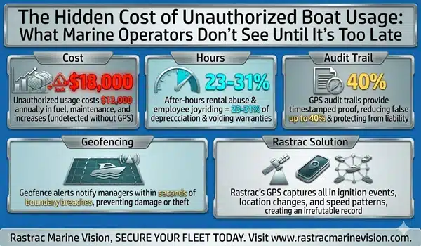
A typical pontoon boat rental season at an established marina generates three to five damage insurance claims per season. One propeller strike on shallow water? Insurance claim. An unscheduled geofence exit? Tow cost. A rented ski boat run aground? Coverage applies until deductibles and claims history catch up.
The problem: traditional rental management systems (Marina Pro, Storable Marine, Boatrax) track bookings and billing, not boat behavior. They don’t know if a renter exceeded 3,000 RPM or drifted outside the rental boundary until damage appears.
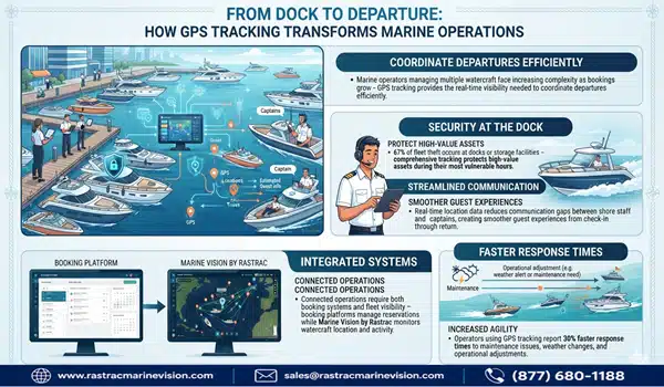
GPS tracking solutions built for watercraft solve this by layering real-time telemetry, geofencing enforcement, and predictive alerts onto your existing rental software. The right platform integrates seamlessly, reduces claims, and recovers stolen personal watercraft within hours instead of days.
This guide identifies the top integration-ready solutions, with emphasis on systems that protect margin without replacing your current operations stack.
Most commercial fleet GPS systems – designed for trucks, vans, and semi-trailers – make three assumptions that break down on the water.
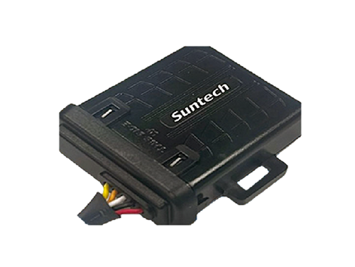
First, they assume cellular-only connectivity. A centerline speedboat operating five miles offshore loses T-Mobile signal. Your GPS unit goes silent. A hybrid cellular/satellite device (like Rastrac’s ST9100) maintains location even in dead zones, essential for coastal rental operations or offshore fishing charters.
Second, they treat speed monitoring as a compliance tool. On land, 65 mph on an interstate is normal. On water, 35 mph in a no-wake zone means collision risk and rental liability. Marine-grade systems enforce speed thresholds by zone – geofence boundaries automatically flag RPM acceleration, not just ground speed.
Third, they ignore salt water and vibration. Generic Bluetooth trackers corrode in weeks. Rastrac’s marine devices use water-resistant enclosures (IP67 rating) and 12V hard-wired installation instead of battery dependency. A solar-powered alternative (BeSol) eliminates charging logistics for anchored pontoon boats or docked jet skis.
Core Advantage: Non-proprietary platform architecture
Rastrac Marine Vision is purpose-built for watercraft fleets. The platform integrates with your existing rental management software (Storable Marine, Marina Genie, Marina Pro) via RESTful Web API and native Google Maps integration. You’re not locked into Rastrac hardware.
Integration Model:
Rental-Specific Features:
Hardware Options (No Vendor Lock-In):
ROI from Integration:
Geofencing + speed monitoring typically delivers:
Integration Timeline:
Boatrax is built specifically for boat rental operators. It combines reservation management, damage reporting, and basic GPS tracking in a single platform.
Strengths: Purpose-built for rentals; damage photo capture and claim documentation integrated; straightforward user interface for rental staff.
Limitations: GPS hardware is proprietary and cellular-only (no satellite option for offshore rentals); API integration with external booking systems is limited; no speed-zone enforcement; data export restrictions.
Best For: Single-location or small multi-location rental operations (under 30 boats) that don’t need offshore capability or external software integration.
Siren Marine embeds sensors throughout a yacht or sportfishing boat – engine, battery, bilge, fuel, through-hull systems – and streams live alerts to your phone.
Strengths: Enterprise-grade reliability; real-time equipment diagnostics; integration with autopilot and navigation systems; strong for charter yacht fleets.
Limitations: High per-unit cost; onboard sensors require professional electrical installation; limited rental management software integration; not practical for high-turnover rental fleets (pontoon boats, jet skis).
Best For: High-value charter operations, multi-week rentals, and professionally managed yacht fleets where equipment health monitoring justifies capital investment.
Before committing, verify that your chosen solution meets these criteria:
API & Software Integration
Marine-Specific Hardware
Rental Operator Features
Transparent Pricing & Support
Mistake #1: Choosing cellular-only GPS for offshore or remote marina rentals
Solution: Verify satellite fallback (Rastrac ST9100) or hybrid coverage from the start. Test coverage in your actual rental areas—don’t assume 4G reaches five miles offshore.
Mistake #2: Selecting a solution that locks you into proprietary hardware
Solution: Choose platforms with open APIs and documented device compatibility. Rastrac’s hardware-agnostic model means you can switch devices or providers without replatforming your entire system.
Mistake #3: Over-investing in onboard monitoring systems built for yachts when you operate pontoon boats and personal watercraft
Solution: Match the solution to your fleet type. Siren Marine is overkill for high-turnover rentals; Rastrac Marine Vision is lean and API-friendly. Boatrax works if you’re not integrating external software.
Q: Does GPS tracking on rental boats increase liability risk if an accident happens?
A: No – GPS tracking reduces liability. Documented speed data, geofence compliance, and maintenance logs demonstrate reasonable risk management. Most insurance carriers offer premium discounts for fleets with active GPS monitoring installed.
Q: Can I integrate GPS tracking without replacing my current reservation system?
A: Yes, if the GPS platform has a documented API. Rastrac integrates via REST API without replacing Storable Marine or Marina Pro; you sync location and maintenance alerts into your existing workflow.
Q: What if a renter disables the GPS unit?
A: Marine-grade devices are hardwired to 12V power, not removable like consumer GPS trackers. Tamper alerts notify you immediately. For high-risk rentals, geofence breach (even with GPS offline) is documented on the rental agreement as a breach-of-contract liability.
Q: How do I calculate ROI for GPS tracking integration into my rental fleet?
A: Start by documenting current annual damage claims, tow costs, theft losses, and insurance deductibles. Then overlay the cost of GPS tracking and maintenance of the system. Most rental operators achieve payback within 12–18 months through damage reduction and theft recovery alone.
Q: Does satellite GPS work for inland lake rentals?
A: Hybrid satellite ST9100 is designed for offshore and remote areas. For inland lakes with cellular coverage, ST4215 is sufficient and costs less. Test actual coverage before committing.
Boat rental profitability depends on fleet utilization and damage prevention. The right GPS tracking solution – integrated into your existing rental management platform, not replacing it – delivers both.
Rastrac Marine Vision stands out for non-proprietary hardware, open API integration, and purpose-built marine features. But evaluation should rest on your specific needs: fleet size, rental geography (coastal vs. inland), existing software stack, and acceptable complexity. Start with a geofencing and speed-monitoring pilot on your highest-damage rental categories (wakeboards, center consoles). Measure claims reduction over 90 days. Scale if ROI justifies.
Request a Demo | Purchase On-line | (877) 680-1188 | Contact Us
Rastrac complements any organization-wide quality assurance program and can help their fleet become the model for operational superiority.
Rastrac helps clients make improvements in processes, organization, financials, communications, and technology. Clients that have taken advantage of Rastrac’s ability to provide solutions tailored to their business are in a wide variety of industries. Rastrac can help you find a solution, too.
We’d love to discuss how we can help you.
Track your boats, watercraft, and vehicles for less than $100/year.
ST4215 +1 year of Rastrac service, available for a limited time.